AN INTERSECTION’S ANCIENT ENERGY Pt. 2

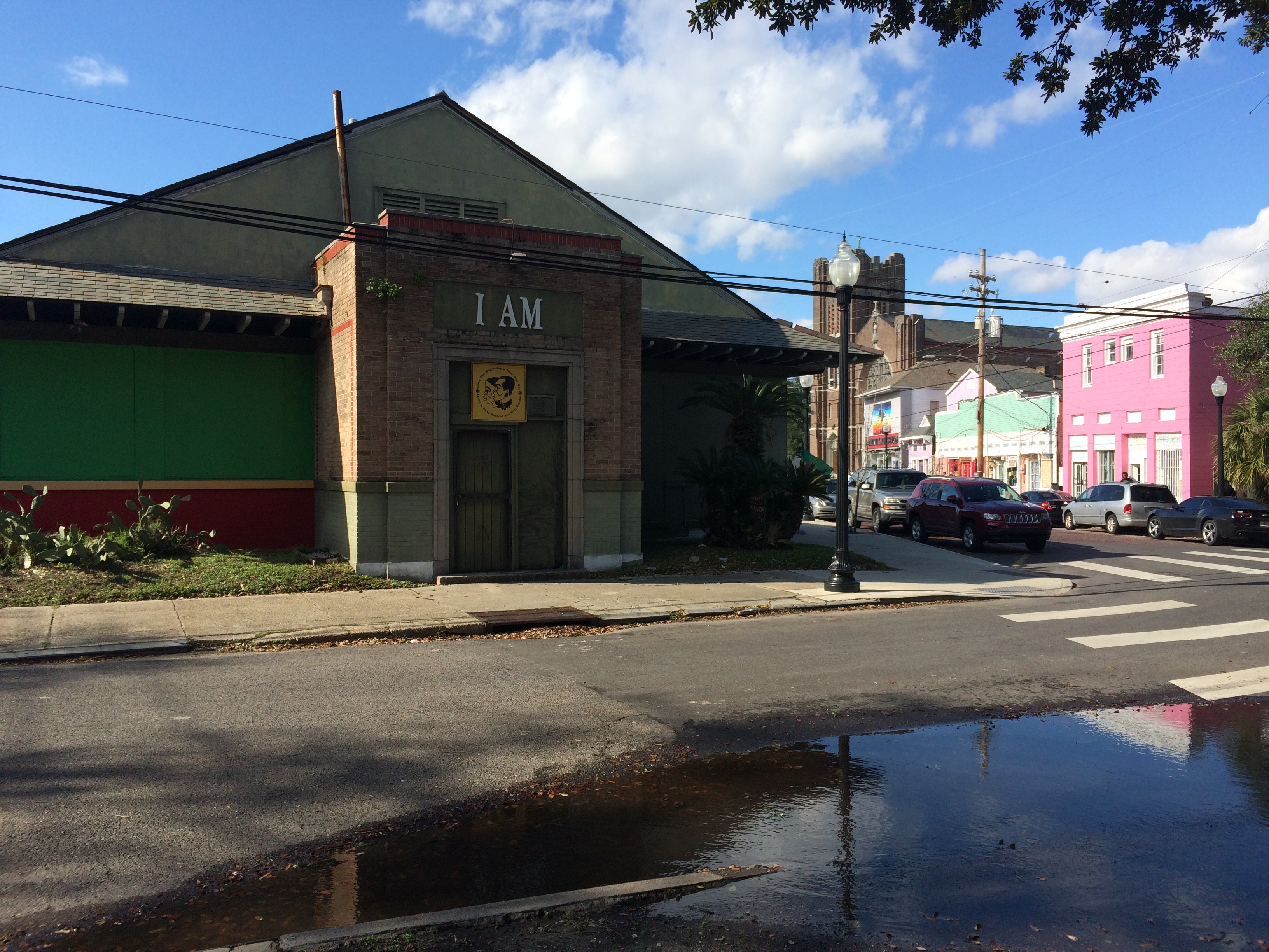
A couple weeks ago, I posted on my favorite New Orleans intersection: where N. Dorgenois, Bell, DeSoto, Kerlerec, and Bayou Road come together—that many-triangled flurry of streets that calls out to me as I walk my dog or pick up a breakfast burrito from Pagoda Cafe. As of my last post, I’d discovered that the site where the Church of I Am That I Am and King and Queen Emporium stands today was also site of the former home of Daniel Clark, prominent Anglo merchant of the Spanish period and the guy responsible for buying up a bunch of plantations between Dorgenois and Bayou St. John and mapping out Faubourg St. John in 1809. But, as I dug deeper, I discovered there was far more to learn….

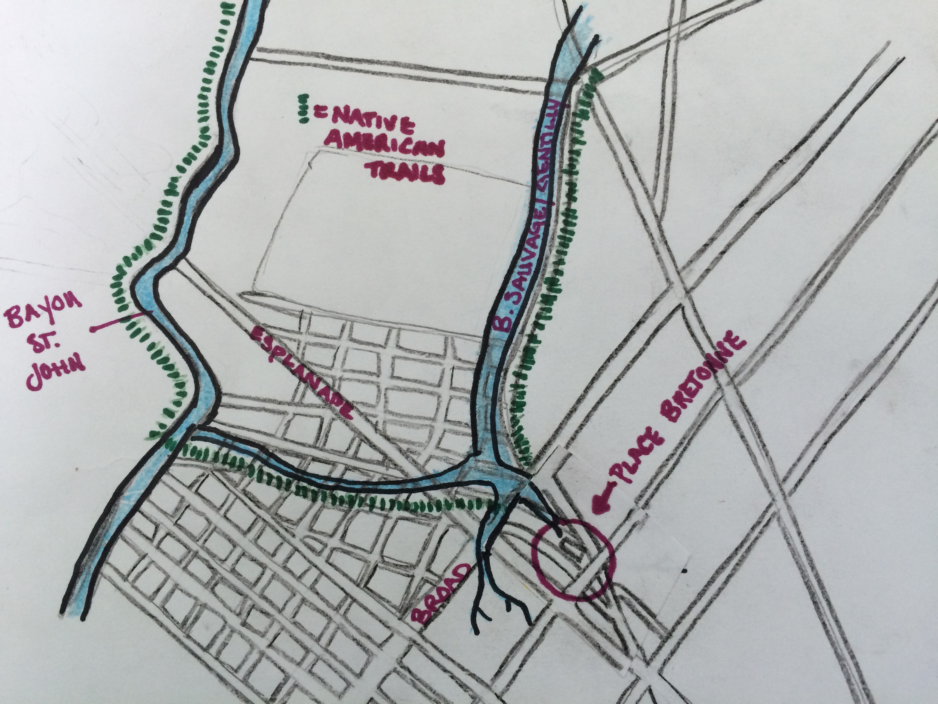
Based on colonial-era maps I’ve scoured, it looks like this intersection was the spot where two well-trafficked Indian trails merged from ancient times up until the French period. One of those was the path that led from Bayou St. John to the present-day French Quarter, that Bayou Road and Bell Street approximate today—the famous portage route that made New Orleans possible. The other path followed along Bayou Sauvage (or Bayou Gentilly, which followed the basic trajectory of present-day Gentilly Boulevard).

My most amateurish map to date! (Not to scale; everything is approximate.)

Based on written evidence and an appropriate dose of educated guessing, it would appear that where these paths came together, Indians from various tribes traded with one another—and this practice continued once Europeans arrived. According to historian Jerah Johnson, “New Orleans’ earliest, as well as its last, all-Indian market was held in an open area called the Place Bretonne at the conjunction of what are now Esplanade Avenue, Bayou Road, and Dorgenois, Bell, and DeSoto streets. It lasted, with gradually dwindling numbers of Indians after 1809 (when the opening of the Faubourg St. John separated it from Bayou St. John, which had been the main route the Indians followed into town), until the construction on that spot of the LeBreton Market building in 1867. Small groups of Indians still continued to sell goods there as well as in other parts of the city.”[1]

According to my research, Clark bought this parcel of land in 1804. He died in 1813 in his hip-roofed house that stood where the Church of I Am That I Am stands today. When he mapped out the future Faubourg St. John, he wanted this fan of streets to be the focal point of the neighborhood and called it “Place Bretonne.” Clearly, as Johnson mentions above, Clark’s decisions essentially closed off Native American trade connections between this site and Bayou St. John. After Clark’s death, the piece of land was sold to the city of New Orleans in 1836, and Johnson tells us a municipal market, called LeBreton Market, was then built on the site in 1867—which is the very same building the aforementioned church occupies today.

I’m still left wondering a bit about this site’s evolution. Did Clark, after buying up the land between Dorgenois and the bayou, simply build a house right where the Indian market had been? What did that look like when it was going down? And then what made the city decide to build a market there 60 years later, after the site had stopped being used for this purpose? Was its ancient past was well-known, and therefore the idea seemed obvious?

I don’t know yet whether there were more specific reasons for this evolution, but it seems to me that the Mississippi River might have everything to do with it. After it swung into its present channel, it left behind the Metairie-Gentilly ridge system that the Native Americans utilized, among many others, to traverse the landscape. Their movement along the ridges impacted the locations they chose for trade, and also influenced the founding of New Orleans in its present location. These pathways also influenced future streets (like Bayou Road) and plantation property lines like the ones that demarcated Clark’s land. Perhaps Clark wanted this site—an important intersection, a center of activity—for his own, and perhaps, after Clark was gone, the city recognized the site’s natural properties for what they were, and decided a municipal market simply belonged there.

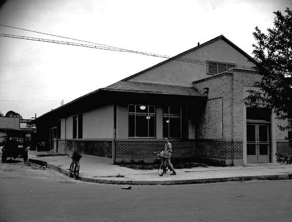
LeBreton Market from Wikimedia Commons, 1938, by an uncredited WPA employee

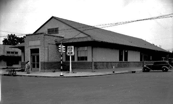
LeBreton Market 1938, credits same as above photograph

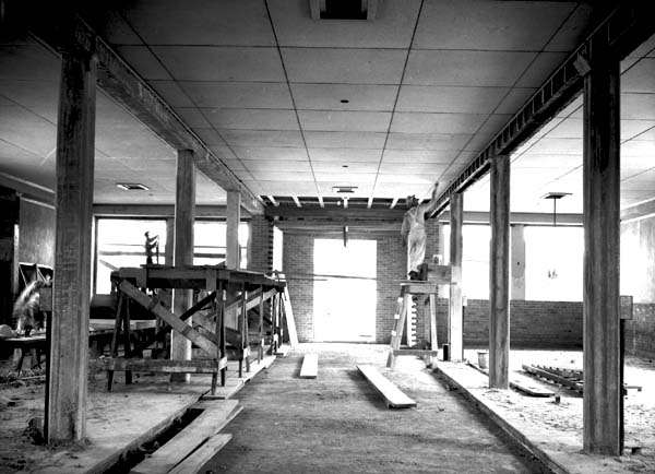
Interior of LeBreton Market during WPA restoration, 1938; credit same as for above photographs

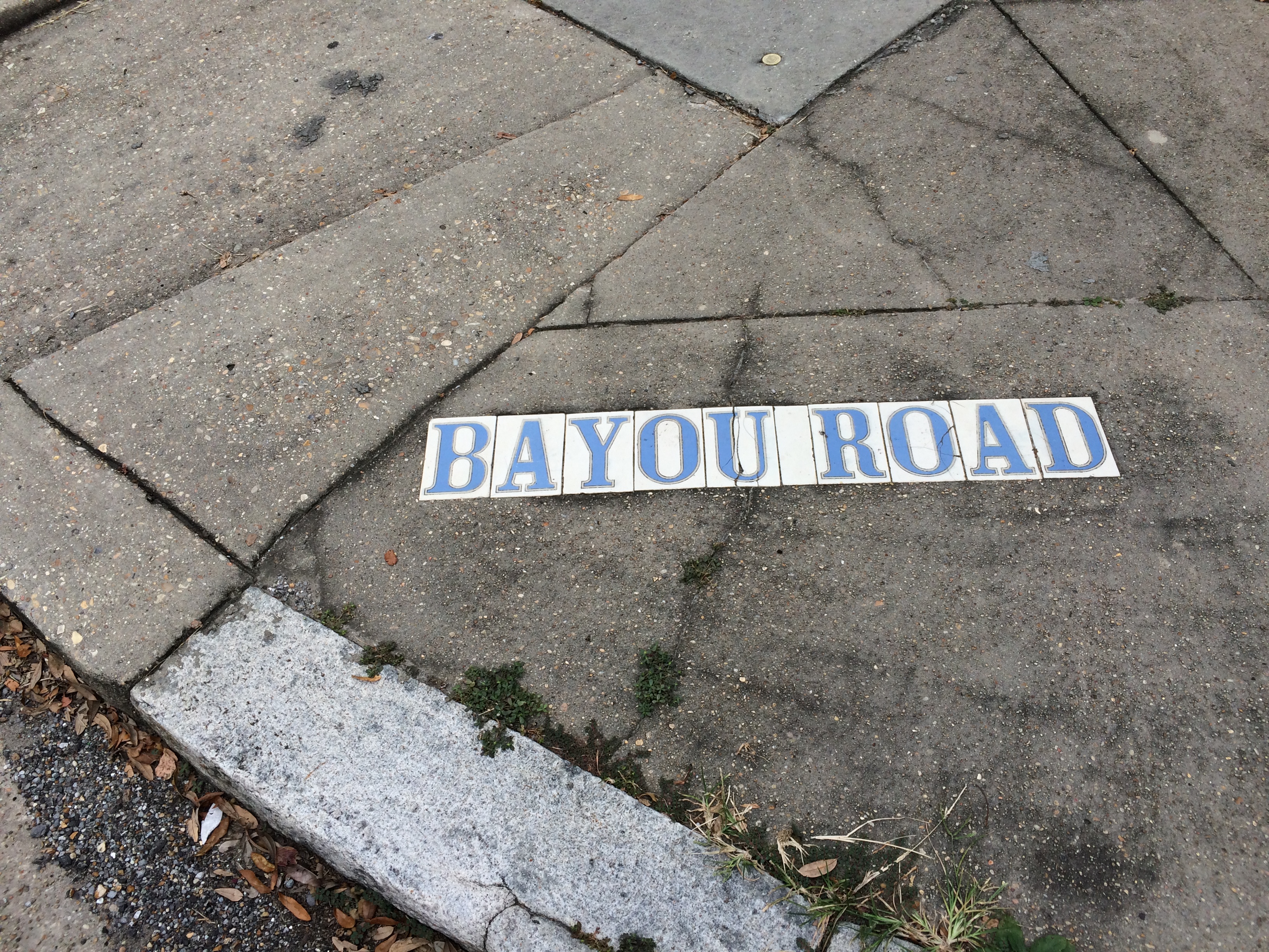
If any of you reading this know more about this intersection than I do, please reach out! All I know is the spot continues to buzz with energy—and now, when I walk my dog across Bayou Road’s brickwork, I can feel how ancient that energy truly is….


  1. Jerah Johnson, “Colonial New Orleans: A Fragment of the Eighteenth Century French Ethos” in Creole New Orleans: Race and Americanization, ed. Arnold R. Hirsch and Joseph Logsdon (Baton Rouge: Louisiana University Press, 1992) 39-40.

FLUNG ROSES AND STOPLIGHT GRAVEYARDS

After a long hiatus, bayou posts are back! I know you’ve been waiting on tenterhooks….

After four months of more general Bayou St. John research, I am about to start focused research for the first chapter of the book—on the bayou’s geomorphic/geographic and Native American history. If anyone has any advice for me—ideas for what to read, who to talk to, etc.—reach out! I get to talk about former Mississippi River pathways, sediment deposits, pirogues, trade routes, slight-but-significant ridges.… CAN’T WAIT.

The past couple weeks, I’ve been on a few bayou adventures.

I biked the almost-100%-completed Lafitte Greenway—a 2.6-mile bicycle and pedestrian trail extending from N. Alexander St., near the base of City Park, to the French Quarter.

New Orleans residents may or may not realize that the Lafitte Greenway follows the path of the former Carondelet Canal, a waterway hand-dug by slaves in the late 18th century, when New Orleans was still under Spanish control, and utilized throughout the 19th century as a commercial conduit between the bayou and the French Quarter. This meant ships laden with goods from settlements north of Lake Pontchartrain or along the Gulf could avoid navigating the Mississippi River altogether and travel through Lake Pontchartrain, down Bayou St. John and into the Carondelet Canal in order to off-load their goods at the rear of the French Quarter.

A vew of the Lafitte Greenway between the bayou and Broad St.

If you ever wondered where old New Orleans stoplights ended up….

The open canal that runs between Broad Street and the bayou, positively gushing as it exits the Broad St. pumping station. Doesn’t it look almost turquoise? Don’t let that fool you. It stinks.

The giant locks at the Broad St. pumping station that control whether water flows up the underground culvert beneath Broad St., or else out to the Orleans outfall canal, via the open canal along the greenway.

There is much more I could (and WILL, in the book) say about the Carondelet Canal. But for now: there is a fabulous (free!) exhibit at the Pitot House on the history of the Carondelet Canal, curated by the Louisiana Landmarks Society, in celebration of the opening of the Lafitte Greenway. So many beautiful old maps and photographs!!! It is both succinct and intensely interesting. I HIGHLY recommend it.

After biking the greenway, I checked out the historic Ossorno House in the Quarter, at 913 Governor Nicholls.

This house was built on the Bayou St. John sometime before 1781 and apparently dismantled and transported, most likely via mule and cart, along Bayou Road to its present location—as were all goods traveling from the bayou to the Quarter before the Carondelet Canal was dug. According to geographic historian Richard Campanella (one of my heroes), in his Geographies of New Orleans: Urban Fabrics Before the Storm, the house is a fine example of a French Creole-style plantation house (although the roof was remodeled sometime in the 1830s)—one of only two plantation-style houses to be found in the French Quarter (the other being Madame John’s Legacy)—which testifies to its rural birth on the bayou. Campanella tells us it’s “the oldest extant structure in the rear of the original city” (106).

I then decided to bike the approximate path of this all-important route along Bayou Road, one of the principal reasons why New Orleans was founded where it was (for access to the river without having to navigate its mouth, as was mentioned above).

In traveling along the (approximate) portage route, one follows Bayou Road, which ends at the crazy, navigationally-nightmarish, odd-angled intersection of Bayou Road, N. Dorgenois, Desoto, Bell, and Kerlerec streets (thank god there’s delicious food right there, at Pagoda Cafe, for the weary, confused traveler) and continues along Bell Street (approximately) to the bayou. The exact location of the original route’s intersection with the bayou was probably somewhere between Bell St. and Desoto (more on this once I continue more in-depth research on the subject).

This terrible panoramic photo (thanks iPhone!) taken from next to Pagoda Cafe, while inaccurate in perspective, I think does justice to the psychological experience of navigating this intersection….

While in this neighborhood, I found…

A historic cornstalk fence at the historic (1870) Dufour-Plassan House.

The approximate general region where Almonaster built a leper hospital in the late 18th century.

An awkward spot where Barracks Street and Bayou Road diverge at a bizarre angle, since Bayou Road does not adhere to the grid plan the rest of the streets in the area adhere to—following, as it does, a natural ridge, the one the Native Americans used to cross the uncrossable swamp between the bayou and what is now the French Quarter.

Finally, I arrived at the bayou itself. Here are a few spots of interest along its banks, a couple of which I was lucky enough to get to go inside of (!!), courtesy of the generous, unsuspecting homeowners I found busying themselves in their front yards.

The house, at 1222 Moss Street, that sits atop what was once a small bayou connecting Bayou St. John and Bayou Sauvage, long since filled in.

What is referred to as “the old Spanish custom house,” although it never officially served as a custom house (there are various theories as to why people refer to it as such). I was lucky enough to get an in-depth tour of the inside of this home (!!!), the owner of which has been painstakingly renovating it for six years. Beneath layers and layers of renovations that have been done over the past two and a half centuries, he has made some amazing discoveries—like anactual iron jail cell, apparently dating from the Spanish colonial period, that the current owner suspects was used to hold folks who were smuggling illegal goods up the bayou, or who perhaps couldn’t pay the toll. ARE YOU KIDDING THAT’S AMAZING.

Below is the plaque that explains a bit more about the house.


Roses that someone had flung into the bayou near the Magnolia Bridge.

And, last but certainly not least, what is perhaps my favorite historic house along the bayou, built in the last decade of the 18th century: “The Sanctuary.” Walter Parker, former mayor of New Orleans, who spearheaded the “beautification” of the bayou in the 1920s and 1930s and who is therefore responsible, in large part, for the bayou as we know it today, once lived in this house. I wasalsolucky enough to be able to see the back courtyard of this home—guarded by a three-hundred-year-old live oak tree that predates the house, and other amazing, old, beautiful things. More on this house, and its many previous owners, to come.