BAYOU ST. JOHN: ACTING UP AGAIN

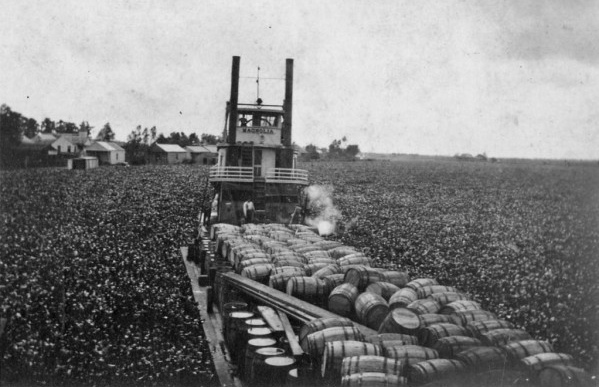
“Water hyacinths blocking a steam boat on a bayou in Louisiana in 1920.” October 25, 1920, photo from Louisiana Works Progress Administration collection. Note: the bayou in the photo is not Bayou St. John.

In writing a recent post on fish in the bayou, I learned a bit about the decision to intermittently reopen, back in 2014, the lock separating the waters of Bayou St. John from those of Lake Pontchartrain. But apparently this most recent debate on a stagnant and unhealthy bayou was not the first of its kind—not at all!

I still have some research to do on the construction of the lock at Robert E. Lee, decisions surrounding bayou health over the course of the 20th century, etc. But until I have all the answers, here are some interesting tidbits on our troublesome friend:

In 1952, a Times-Picayune headline claimed: “Bayou St John Acting Up Again: Surface Scum Permeating Area with Bad Odor.” A caption beneath a photo of the weed-choked bayou read: “Malodorous Stuff Blankets Water Near City Park Entrance.” I’ve decided we don’t use the word “malodorous” enough anymore…. let’s resurrect it (just in time for Mardi Gras)!

The article goes on to explain: “Members of the Bayou St. John Improvement Association reported Friday that scum forming on the surface of the bayou has permeated the area with a gagging smell….” Public Buildings and Parks Commissioner Victor H. Schiro noted that this phenomenon was certainly not isolated (“‘We have [this] trouble every year…’”) nor was it a small problem: “‘All week we’ve had a crew of six to eight men collecting the scum off the water. They’ve moved six truckloads of the stuff all ready. We’ll probably be doing this for another month.’” Wow. That’s a lot of scum.

Schiro said he didn’t quite understand the phenomenon, but attributed it to vegetation growing on the bed of the bayou that, during certain times of year, rose to the surface. “‘It’s like a flower that comes to bloom,’” he said.

The article wraps up with a final thought from Schiro: “‘There’s not much we can do about this except to try to keep the bayou clean….Whenever we say anything about closing the bayou the people raise the devil, so we do the best we can under the circumstances.’” All around the city, open canals were being buried and covered over, including the bayou’s younger sister, the New Basin Canal. Therefore, filling in the bayou to avoid this kind of nuisance wasn’t a fanciful idea. Nonetheless, the bayou was clearly as beloved then as it is now, despite its smelly antics. [1]

One more fun fact: in 1953, they were back at it, trying to get rid of the problematic vegetation. A Times-Picayune headline read: “Bayou Clearing Work is Started, But Undergrowth’s Weight Brings Halt for Repair.” I will quickly summarize the gist of the article: a war surplus amphibious “duck,” a 2.5-ton, six-wheel “truck and barge combined, equipped with a propeller and capable of locomotion on land and water,” outfitted with a special metal basket at the end of a boom, was being used to clear the bayou of its organic mess. However, this amphibious behemoth was no match for the bayou’s impressive undergrowth. The weight of it broke the boom, and the “duck” had to be sent back to the Sewerage & Water Board for repairs. The bayou was said to have tweeted: #sorrynotsorry #iamwhoiam[2]

1. Times-Picayune 21 Jun. 1952: 6. NewsBank. Web. 7 Feb. 2017
2. Times-Picayune 23 Jul. 1953: 1. NewsBank. Web. 7 Feb. 2017.

BAYOU BIKE RIDE

Over the weekend, my best-adventure-companion Lauren Gauthier and I took a bike ride from the bottom of the bayou to the top. That is, from Jefferson Davis Parkway to Lake Pontchartrain, the brackish estuary that serves as the bayou’s water source (and that is also home to, supposedly, the longest, continuous bridge in the world). We biked along the bayou’s crooked southern section—arguably the most historic, since most of the original planters in the Bayou St. John area made their homes there, beginning in 1708, and since much of the Faubourg St. John’s most historic homes can be found along Moss Street, the charming street split down the middle by the bayou itself.

(Planters wanted land near the southern end of the bayou because it’s the most suitable for agriculture. It’s the most suitable for agriculture a) because it’s above sea level and b) because it was chock-full of nutrient-rich Mississippi River sediment. It’s both of those things because the ridges around the bayou’s southern half—Gentilly and Metairie Ridges—were former natural levees of a former distributary of the Mississippi River, formed by the river overtopping its banks and dumping its sediment in the process.But I digress!)

We then cut through City Park…

The statue of Confederate General P.G.T. Beauregard, one of several Confederate monuments the city is considering removing, at the entrance to City Park.

Will Ryman’s rose blossom sculpture, set up in City Park as part of Prospect 3.

Cypress trees: north of Gentilly and Metairie Ridges, the land around the bayou toward the lake was primarily swampland and cypress forest before the city drained it in the early 20th century.

Beautiful old building in City Park. Does anyone know what this is/was?

View from beneath the Wisner overpass, leaving City Park…

and cut back toward the bayou bike path…

Imagining I am a Houma Indian or a French explorer from the 17th century, scanning the bayou from the underbrush…ignore those buildings on the far bank.

It’s hard to make out, but the right edge of that property marks the southern tip of Park Island, created because the bayou made a sharp curve here back in the day, and, because of the stream feeding it at this point and filling it up with silt and sand, folks decided it was too difficult to navigate and so dredged an additional straight path for the bayou to travel. Now it “flows” (a bayou doesn’t really “flow”) around the piece of land created when they sliced it straight.

Bayou natives on a Sunday stroll.

The lock at Robert E. Lee Boulevard, referred to as the “old flood control structure,” built in 1962. Slated to be removed when the newer flood control structure was built closer to Lake Pontchartrain in 1992, but because of lack of funding was never removed.

Above Robert E. Lee, on the west bank of the bayou, we find the colloquially-named “Spanish Fort,” built to protect the city of New Orleans from invaders from the north. Because of the bayou’s important position as part of the “lake route,” which many ships would take instead of fighting their way up the mouth of the Mississippi River, it was important to keep the mouth of the bayou extra fortified. See pictures below.

See the bayou “flowing” languidly by….

Also, does anyone know what this…

Or this is?? Located near the Spanish Fort. What am I looking at?

<

Knock knock! Who’s in this grave?? Also near the Spanish Fort. I’ve heard a folktale about this…something about a Spanish soldier, an Indian princess, and an angry Indian Chief. Somehow I question this storyline…. Anybody got any info?

And finally we reached the lake!

Where the bayou meets the lake. Once a major destination for boating and swimming…

…until this puppy was built in the 1990s for flood-control purposes. Post-Katrina, there has been much debate between the New Orleans Levee Board, in charge of flood-control, and scientists and residents regarding whether or not the bayou should be opened back up to the lake, except in times of potential flooding. Doing so would improve water quality, encourage swimming critters of all kinds to come back, and would enhance recreational use of the bayou. As of 2014, there was talk of opening this lock more often. I don’t see much recent news on the subject. Does anyone know more about what’s currently happening here?

Naturally-occurring New Orleans rocks, i.e. sandbags.

Critter bones.

Last but not least, the feathered guardian of this liminal space between locked-up bayou and Lake Pontchartrain.