WPA PHOTO COLLECTION DETOUR

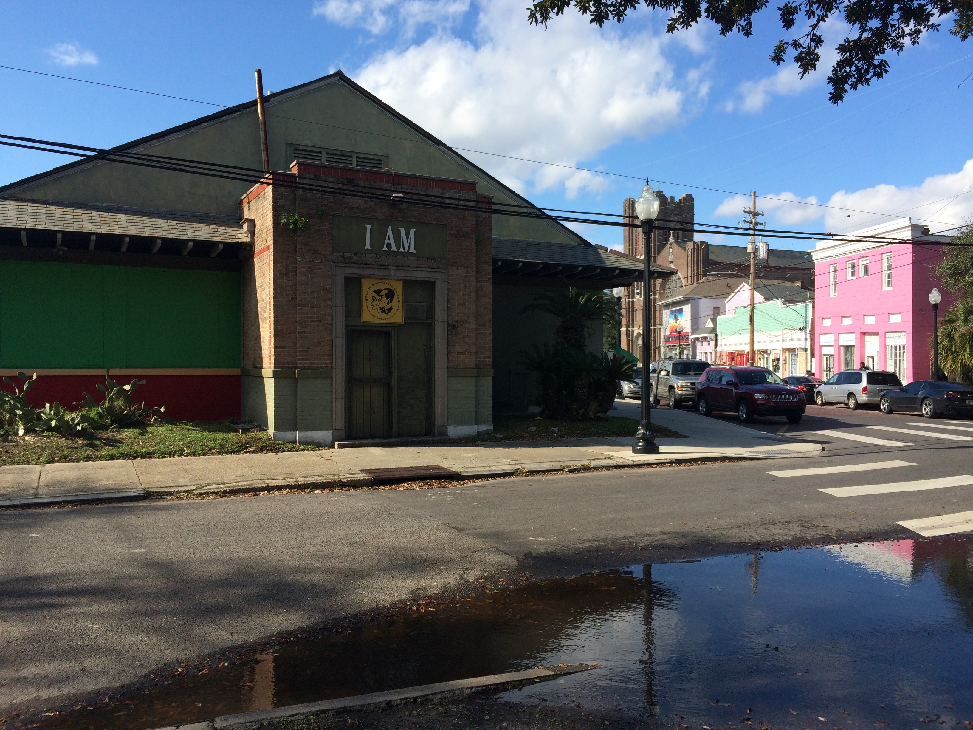
For the past few weeks, I’ve been searching for images to use in the bayou book—combing the digital holdings of the Library of Congress, the Louisiana Digital Library, the New Orleans Public Library and about a billion other institutions, not to mention desperately attempting to track down details about unattached (but often wonderful!) historic images on Wikimedia Commons and personal blogs.

In my travels, I came across a heap of digitized WPA photographs at the NOPL. The photos cover a huge variety of WPA projects unfolding all over the city in the 1930s and 40s, and many of them are fairly mundane—but a seemingly equal number are totally fascinating.

I hope everyone will forgive me if I stray a bit from the bayou in this week’s post….

The photos took me on an adventure, and I couldn’t resist!

I clicked around, and decided to present some gems I found—of women and children in particular.


Photo #1: June 1941, from the series entitled, simply, “Mattresses.”

The finding aid explains a bit further: “WPA workers manufactured 17,682 mattresses and quilts to be distributed to the needy during 1939.”

I love how tangible this photo feels—those slats, the piles of fabric, the aprons!


Photo #2 & #3: September, 1937, from a series called “Archaeoconchology.”

I know, right?! Who is this amazing woman! To whom is she calling?! So it turns out “archaeoconchology,” when entered into the Google search bar, turns up a grand total of 9 (obscure) entries. One hesitates to say it’s not a real word…. The only quasi definition I was able to turn up said it was a branch of archaeozoology.

Basically, someone was collecting some sea shells, perhaps studying them, and otherwise having this woman in her amazing dress pose with them.


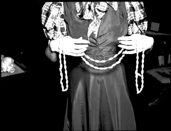
Photo #4: From September 1940, from series called “Household Aide”

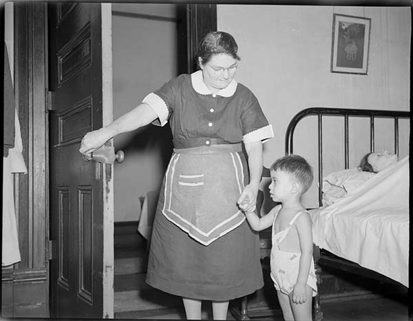
The finding aid explains that these photos feature a “training center for household aid workers. Photographs show Mrs. Eva Blackwell, assistant supervisor, with workers in the ‘carpentry’ shop and Mrs. Leila Schneidau teaching workers the proper care of patients.” In this particular shot, we see what I assume is a “worker” leading a little boo into another room. This child has completely won over my heart! But what makes this photo *extra* special is what I believe is a mannikin lying in bed in the background. There were other photos of mannikin patients, so I think it’s a safe bet. Also, just look at her.…


Photo #5: From January, 1940, from a series called “Music.”

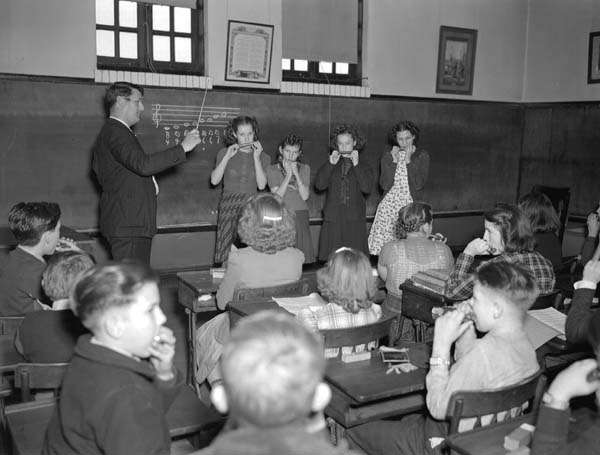
The following description confirms what you think you’re seeing: “Harmonica class at Robert C. Davey School, 1307 Dryades Street. Jimmy Dillon, 14, 1621 Dryades; Rita Van Court, 13, 1824 Terpsichore; Gladys Luc, 13, 908 Howard; Anna Paladino, 15, 1400 Baronne.” Why aren’t harmonica lessons a part of music class in public schools nowadays?! Practicing my scales with my classmates at the front of the room, with that wand waving about in front of me—what could be better?! What’s also wonderful is we have names and addresses for some of the students. If any readers recognize grandparents or addresses, please comment!


Next post, it’s back to the bayou—I promise! But I seriously recommend clicking around this collection at the NOPL in the meantime.


All photos from WPA Photograph Collection, Louisiana Division, New Orleans Public Library.

1. Mattresses, 27.03 “Matress Making Project,” 6/12/1941, #10.

2 & 3. Archaeoconchology, 04.02 , “Shell Project Story at the Louisiana State Museum,” 9/29/1937, #7 & #8.

4. Household Aide, 22.01, 9/18/1940, #10.

5.  Music, 30.07, “Federal Music Project,” 1/10/1940, #1.

AN INTERSECTION’S ANCIENT ENERGY Pt. 2

A couple weeks ago, I posted on my favorite New Orleans intersection: where N. Dorgenois, Bell, DeSoto, Kerlerec, and Bayou Road come together—that many-triangled flurry of streets that calls out to me as I walk my dog or pick up a breakfast burrito from Pagoda Cafe. As of my last post, I’d discovered that the site where the Church of I Am That I Am and King and Queen Emporium stands today was also site of the former home of Daniel Clark, prominent Anglo merchant of the Spanish period and the guy responsible for buying up a bunch of plantations between Dorgenois and Bayou St. John and mapping out Faubourg St. John in 1809. But, as I dug deeper, I discovered there was far more to learn….

Based on colonial-era maps I’ve scoured, it looks like this intersection was the spot where two well-trafficked Indian trails merged from ancient times up until the French period. One of those was the path that led from Bayou St. John to the present-day French Quarter, that Bayou Road and Bell Street approximate today—the famous portage route that made New Orleans possible. The other path followed along Bayou Sauvage (or Bayou Gentilly, which followed the basic trajectory of present-day Gentilly Boulevard).

My most amateurish map to date! (Not to scale; everything is approximate.)

Based on written evidence and an appropriate dose of educated guessing, it would appear that where these paths came together, Indians from various tribes traded with one another—and this practice continued once Europeans arrived. According to historian Jerah Johnson, “New Orleans’ earliest, as well as its last, all-Indian market was held in an open area called the Place Bretonne at the conjunction of what are now Esplanade Avenue, Bayou Road, and Dorgenois, Bell, and DeSoto streets. It lasted, with gradually dwindling numbers of Indians after 1809 (when the opening of the Faubourg St. John separated it from Bayou St. John, which had been the main route the Indians followed into town), until the construction on that spot of the LeBreton Market building in 1867. Small groups of Indians still continued to sell goods there as well as in other parts of the city.”[1]

According to my research, Clark bought this parcel of land in 1804. He died in 1813 in his hip-roofed house that stood where the Church of I Am That I Am stands today. When he mapped out the future Faubourg St. John, he wanted this fan of streets to be the focal point of the neighborhood and called it “Place Bretonne.” Clearly, as Johnson mentions above, Clark’s decisions essentially closed off Native American trade connections between this site and Bayou St. John. After Clark’s death, the piece of land was sold to the city of New Orleans in 1836, and Johnson tells us a municipal market, called LeBreton Market, was then built on the site in 1867—which is the very same building the aforementioned church occupies today.

I’m still left wondering a bit about this site’s evolution. Did Clark, after buying up the land between Dorgenois and the bayou, simply build a house right where the Indian market had been? What did that look like when it was going down? And then what made the city decide to build a market there 60 years later, after the site had stopped being used for this purpose? Was its ancient past was well-known, and therefore the idea seemed obvious?

I don’t know yet whether there were more specific reasons for this evolution, but it seems to me that the Mississippi River might have everything to do with it. After it swung into its present channel, it left behind the Metairie-Gentilly ridge system that the Native Americans utilized, among many others, to traverse the landscape. Their movement along the ridges impacted the locations they chose for trade, and also influenced the founding of New Orleans in its present location. These pathways also influenced future streets (like Bayou Road) and plantation property lines like the ones that demarcated Clark’s land. Perhaps Clark wanted this site—an important intersection, a center of activity—for his own, and perhaps, after Clark was gone, the city recognized the site’s natural properties for what they were, and decided a municipal market simply belonged there.

LeBreton Market from Wikimedia Commons, 1938, by an uncredited WPA employee

LeBreton Market 1938, credits same as above photograph

Interior of LeBreton Market during WPA restoration, 1938; credit same as for above photographs

If any of you reading this know more about this intersection than I do, please reach out! All I know is the spot continues to buzz with energy—and now, when I walk my dog across Bayou Road’s brickwork, I can feel how ancient that energy truly is….


  1. Jerah Johnson, “Colonial New Orleans: A Fragment of the Eighteenth Century French Ethos” in Creole New Orleans: Race and Americanization, ed. Arnold R. Hirsch and Joseph Logsdon (Baton Rouge: Louisiana University Press, 1992) 39-40.

WHAT THE BAYOU HAS TAUGHT ME SO FAR

What I’ve learned from my first week of research: enter research institution with a full stomach and an empty bladder; do not attempt to plan how long you’ll spend with any given source—you’ll never know what you’ll find, or where it will lead you, or the time required for s​uch adventures; I can’t remember what else I’ve learned, because I’m exhausted.

This past week I read about a ghost cemetery that once existed alongside the bayou, near the Lafitte Greenway. Not a cemetery full of ghosts—those are all over New Orleans—but a cemetery that has become a ghost itself: briefly in use in the mid-19th c. and then “filled in” (What does that mean? What did they do with the bodies??) after just two or three decades, due to a land dispute I need to learn more about. The cemetery was intended to be half Protestant, half Catholic, with each half further divided into sections for whites, free people of color, and slaves.

Mostly, I’ve been rifling through boxes filled with folders filled with tissue-thin letters written on typewriters from 1933-1936 about the WPA-funded Bayou St. John Aquatic Park Project—when that mucky, rubbish-filled, houseboat-infested water was swept clean of its refuse, dredged, leveed, straightened, decked out with grassy banks and flowering bushes and newly paved highways, strapped with fixed-span bridges.… No more ragamuffin children in underwear jumping from broken bridges! Only gondolas, and ladies in nice hats!

I don’t mean to make fun of those fine men whose letters back and forth to one another (letters, I imagine, that were dictated to secretaries as said men paced the floor, gesticulating wildly, like in the movies) I’ve been immersed in all week. The historian’s role is not to judge (but this is a blog, after all…). I actually might miss Walter Parker, Chairman of the Bayou St. John Improvement Association, once I have to move on to other sources. Walter Parker—a man with vision and persistence and the ability to persuade, who is largely responsible for the bayou we all know and love today….

P.S. I’m in the market for a cheap canoe, or a reliable floating-something of any kind, and a single paddle. (Oh! And a doggie lifejacket, size small!)

Photo credit: Lauren Gauthier. Magnolia Bridge, looking up.