BAYOU ST. JOHN: ACTING UP AGAIN

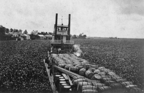
“Water hyacinths blocking a steam boat on a bayou in Louisiana in 1920.” October 25, 1920, photo from Louisiana Works Progress Administration collection. Note: the bayou in the photo is not Bayou St. John.

In writing a recent post on fish in the bayou, I learned a bit about the decision to intermittently reopen, back in 2014, the lock separating the waters of Bayou St. John from those of Lake Pontchartrain. But apparently this most recent debate on a stagnant and unhealthy bayou was not the first of its kind—not at all!

I still have some research to do on the construction of the lock at Robert E. Lee, decisions surrounding bayou health over the course of the 20th century, etc. But until I have all the answers, here are some interesting tidbits on our troublesome friend:

In 1952, a Times-Picayune headline claimed: “Bayou St John Acting Up Again: Surface Scum Permeating Area with Bad Odor.” A caption beneath a photo of the weed-choked bayou read: “Malodorous Stuff Blankets Water Near City Park Entrance.” I’ve decided we don’t use the word “malodorous” enough anymore…. let’s resurrect it (just in time for Mardi Gras)!

The article goes on to explain: “Members of the Bayou St. John Improvement Association reported Friday that scum forming on the surface of the bayou has permeated the area with a gagging smell….” Public Buildings and Parks Commissioner Victor H. Schiro noted that this phenomenon was certainly not isolated (“‘We have [this] trouble every year…’”) nor was it a small problem: “‘All week we’ve had a crew of six to eight men collecting the scum off the water. They’ve moved six truckloads of the stuff all ready. We’ll probably be doing this for another month.’” Wow. That’s a lot of scum.

Schiro said he didn’t quite understand the phenomenon, but attributed it to vegetation growing on the bed of the bayou that, during certain times of year, rose to the surface. “‘It’s like a flower that comes to bloom,’” he said.

The article wraps up with a final thought from Schiro: “‘There’s not much we can do about this except to try to keep the bayou clean….Whenever we say anything about closing the bayou the people raise the devil, so we do the best we can under the circumstances.’” All around the city, open canals were being buried and covered over, including the bayou’s younger sister, the New Basin Canal. Therefore, filling in the bayou to avoid this kind of nuisance wasn’t a fanciful idea. Nonetheless, the bayou was clearly as beloved then as it is now, despite its smelly antics. [1]

One more fun fact: in 1953, they were back at it, trying to get rid of the problematic vegetation. A Times-Picayune headline read: “Bayou Clearing Work is Started, But Undergrowth’s Weight Brings Halt for Repair.” I will quickly summarize the gist of the article: a war surplus amphibious “duck,” a 2.5-ton, six-wheel “truck and barge combined, equipped with a propeller and capable of locomotion on land and water,” outfitted with a special metal basket at the end of a boom, was being used to clear the bayou of its organic mess. However, this amphibious behemoth was no match for the bayou’s impressive undergrowth. The weight of it broke the boom, and the “duck” had to be sent back to the Sewerage & Water Board for repairs. The bayou was said to have tweeted: #sorrynotsorry #iamwhoiam[2]

1. Times-Picayune 21 Jun. 1952: 6. NewsBank. Web. 7 Feb. 2017
2. Times-Picayune 23 Jul. 1953: 1. NewsBank. Web. 7 Feb. 2017.

A PICTORIAL TOUR OF THE LAFITTE GREENWAY

If you didn’t get a chance to make it out to the 10th annual  Lafitte Greenway hike last Saturday, well have no fear! I took lots of photos and notes for you!


The hike of the recently-opened bicycle and pedestrian trail that follows along the filled-in bed of the old Carondelet Canal (the waterway that connected Bayou St. John to the edge of the French Quarter from the 1790s until the early 1900s) began in Congo Square, at 10am sharp. Hundreds of sunscreened people milled about and formed groups around volunteer tour guides. One of the founders of Friends of Lafitte Greenway, Bart Everson, gave a short speech—and soon enough, the groups were off!

After crossing Basin Street, named after the turning basin where the Carondelet Canal once culminated, we began strolling down the Greenway. Volunteer tour guide Kevin Centanni (who recently purchased the abandoned 10th Precinct Police Station near Delgado and is teaming up with Susan Spicer to open a restaurant in the renovated space, hopefully sometime in the next few months) told us all about the following fascinating features as we walked along:


–The gravel path to the right of the Greenway, where the Lafitte Projects once stood, that gives a nod to the “lover’s lane” that once ran alongside the canal in its early days. City residents would escape the hustle and bustle of the French Quarter and stroll hand-in-hand along the canal, taking in the relative quiet and breathing in the fresh air. This pathway is lined with old stones reclaimed from foundations of demolished buildings that were once in the area.

–The old brick posts that once marked the entrance to the Lafitte Projects. Centanni reminded us that Iberville and Lafitte were once sister housing projects of a sort—one for whites, and one for blacks—across the street from one another.

–A soon-to-be-finished storm water retention pond (among others along the Greenway). Eventually, the pond will hold rainwater and allow it seep back into the surrounding land instead of being pumped out into Lake Pontchartrain.

–Something called an “eco-swale,” which Centanni defined as a “ditch with the right kinds of plants in it.” I don’t know much about how these special ditches function yet, but the idea is to plant native species there in order to promote filtration of runoff into the surrounding land.

–Mr. Fred’s garden, one of the first along the Greenway, behind the Sojourner Truth Neighborhood Center.

–An example of “permeable pavement,” which is just what it sounds like: pavement that allows water to seep through it so it can flow back into the ground instead of spilling off into streets and storm drains.

–The Broad Street pumping station and the open canal that empties into it, recently fenced off for pedestrian safety.

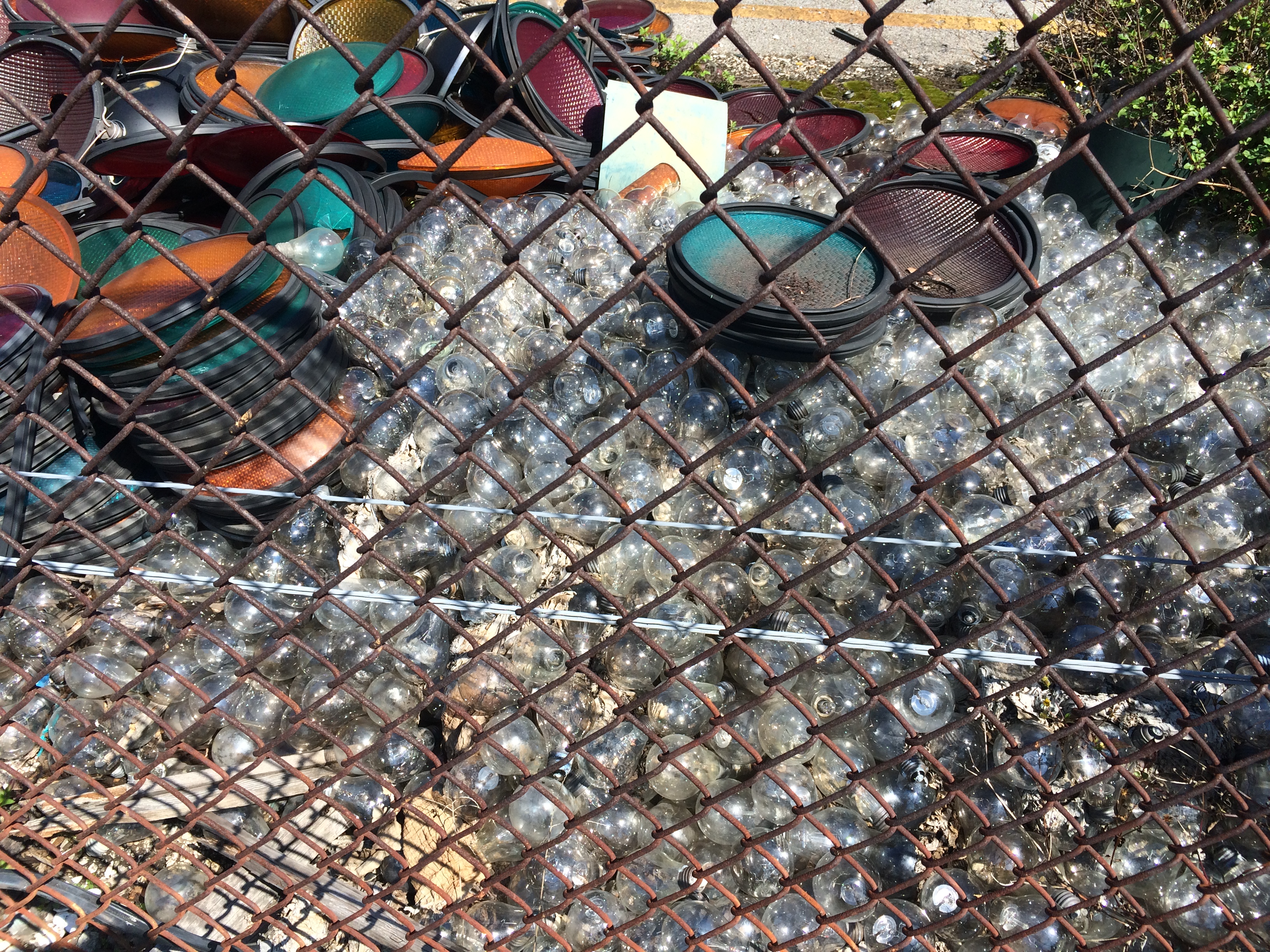
–The “stoplight graveyard” I mentioned in a previous blog post about the Lafitte Greenway (soon to be removed and turned into green space along the trail, says Centanni), where the city piles up broken stoplights and lightbulbs. Don’t the bulbs look like fish eggs?

–The small memorial for David Lee Thompson, who died when attempting to cross a bridge over the canal running alongside the Greenway last December. The bridges have been fenced off to try and prevent people from using them, but they remain in place.

-What?!? Public recycling receptacles in New Orleans?!?!

–Where the Lafitte Greenway passes below Bayou St. John: the spot where the bayou once flowed into the Carondelet Canal, where the top of the “L” met its bottom leg and shot off toward the Quarter. Well…it didn’t exactly shoot, but sort of trickled its way down there—often becoming clogged and impassable, exasperating residents and officials time and time again for decades.

–Sydney Torres’ property, stretching from Jefferson Davis toward Rouses, planned to become a high-end residential and retail space. 

–Some pretty impressive graffiti along the side of a building on Torres’ property.

–A fully-equipped bike repair station (!!!) next to Winn Dixie along the Greenway.

–Where the Greenway ends for the timing being, at N. Alexander Street.

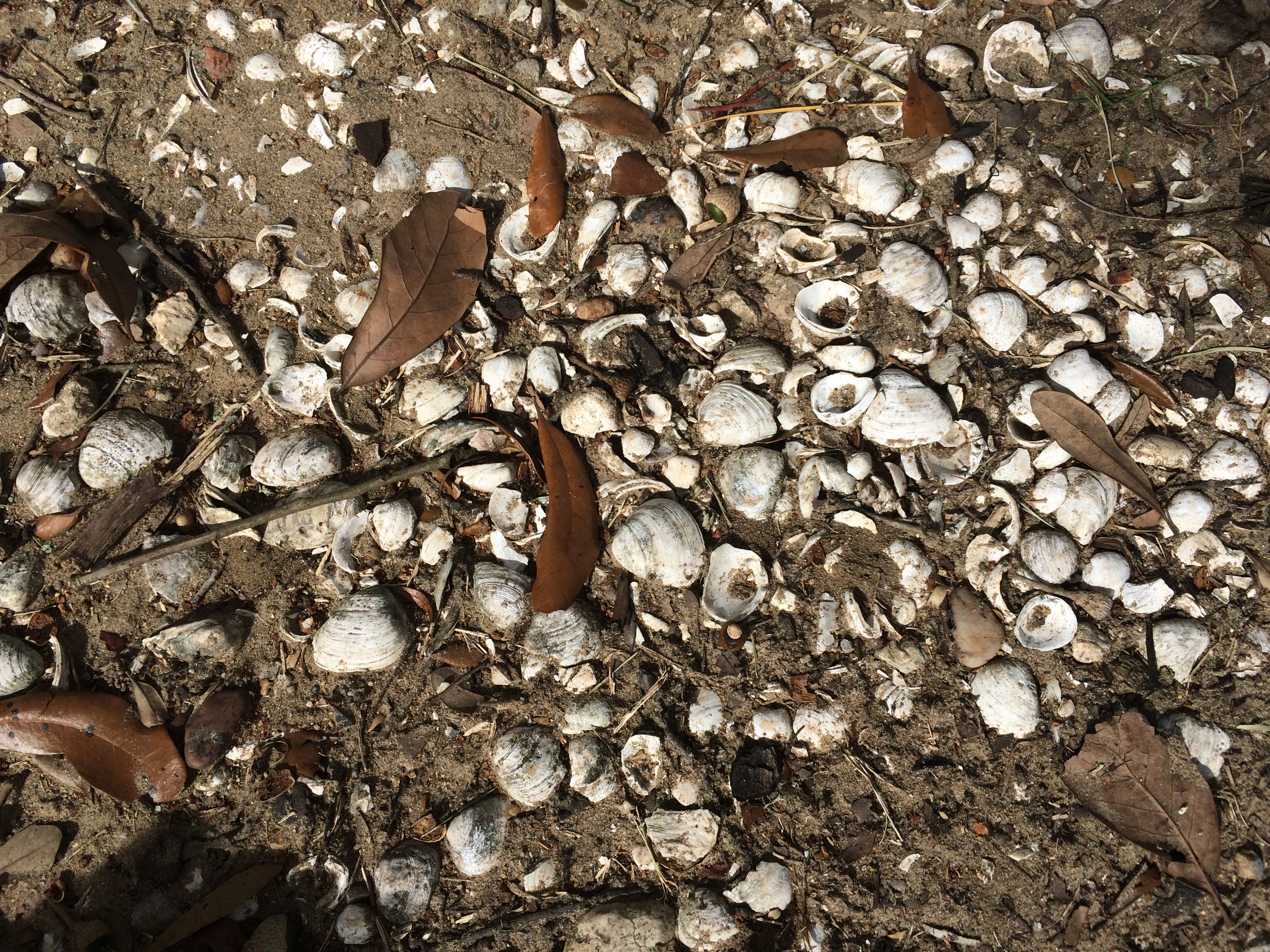
–A pothole full of clam shells that sets me musing about the shells’ possible connection to Indian middens found in the vicinity of Metairie Road….

–And finally, the hike’s final stop at Second Line Brewing! It was a blast to hike the Greenway, learning about the corridor’s many-layered history as we walked along. If I missed anything, reach out and share!

One more thing: you know how I mentioned those hoards of sunscreened folks preparing to set off in Congo Square? Well I was not one of them. As in, I did not wear sunscreen, and ended up with a mega legging calf-burn! Embarrassing, but too funny not to share!

ANCIENT AND ODD-ANGLED: THE ROAD TO BAYOU ST. JOHN

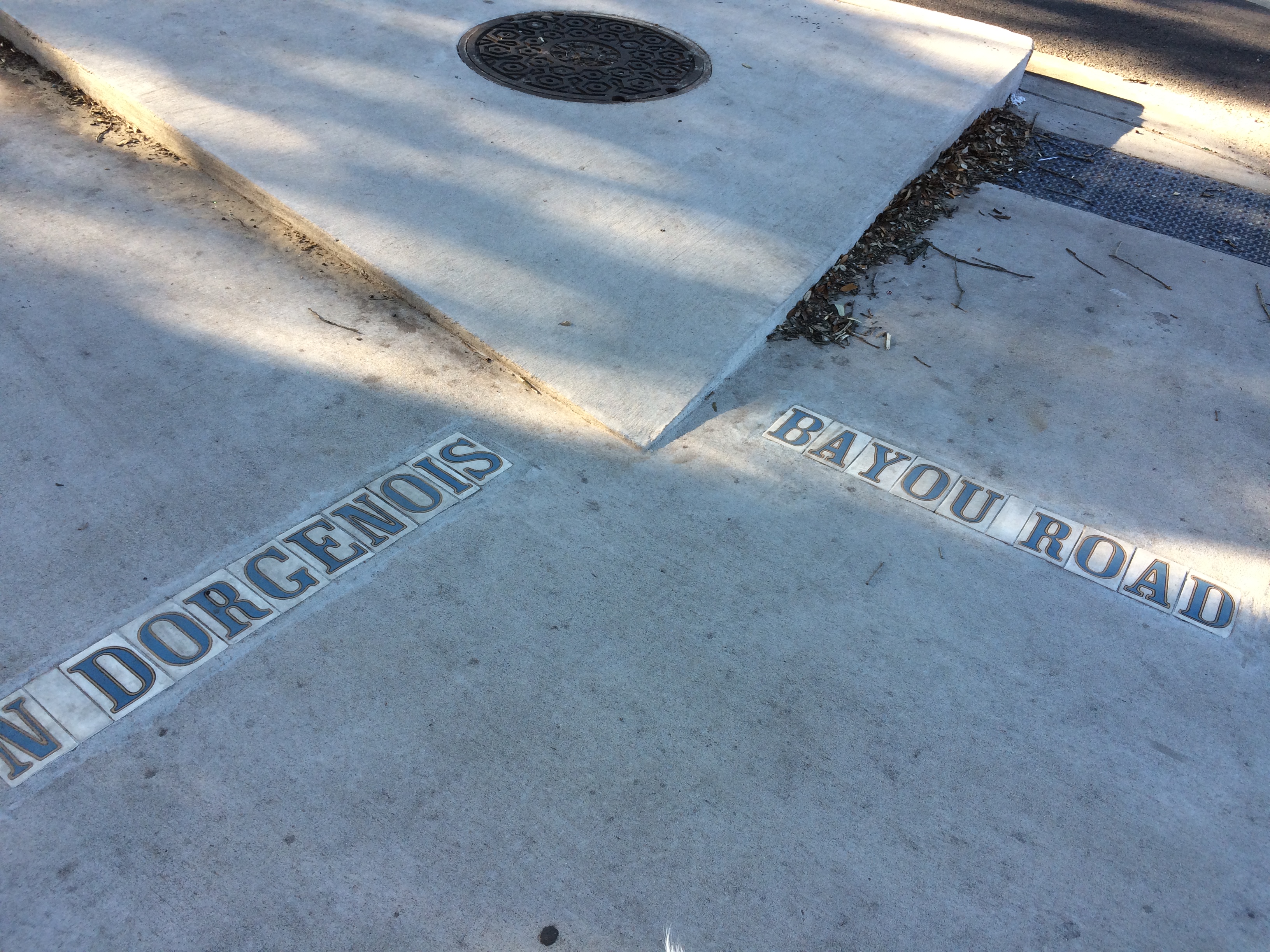
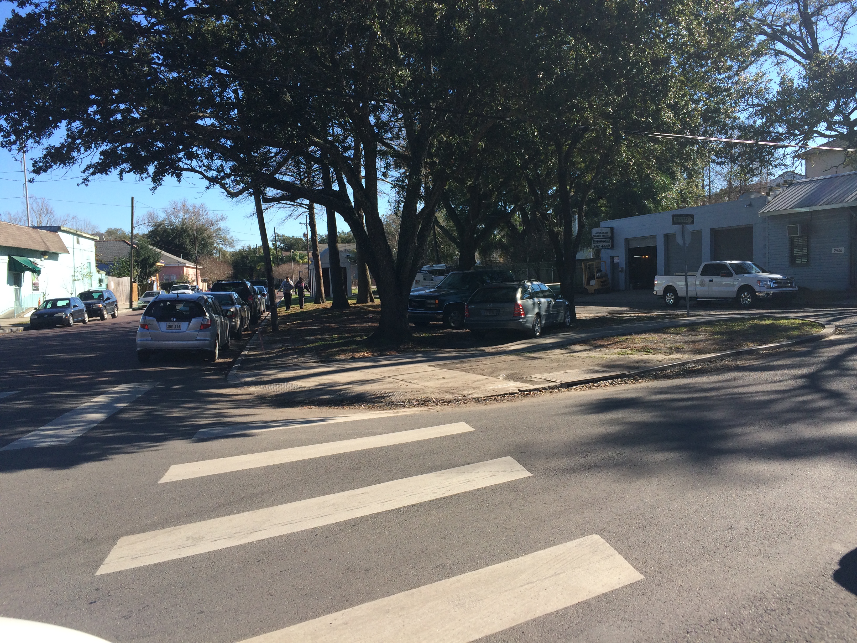
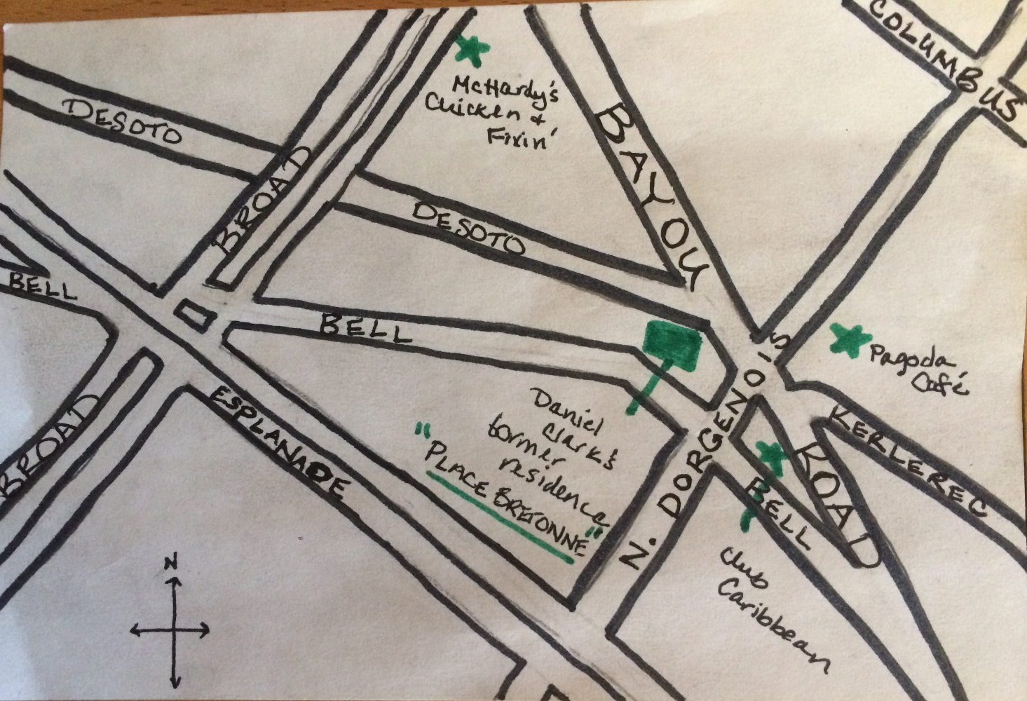
Since moving to my new address on N. Dorgenois Street, my fascination with the charming and disorienting formation of streets between Esplanade, N. Rocheblave, Columbus, and Broad has only grown. Residents may know this spot as home to Pagoda Café, Club Caribbean, and McHardy’s Chicken.

From N. Dorgenois, facing Bayou Road and Bell Street. photo by author

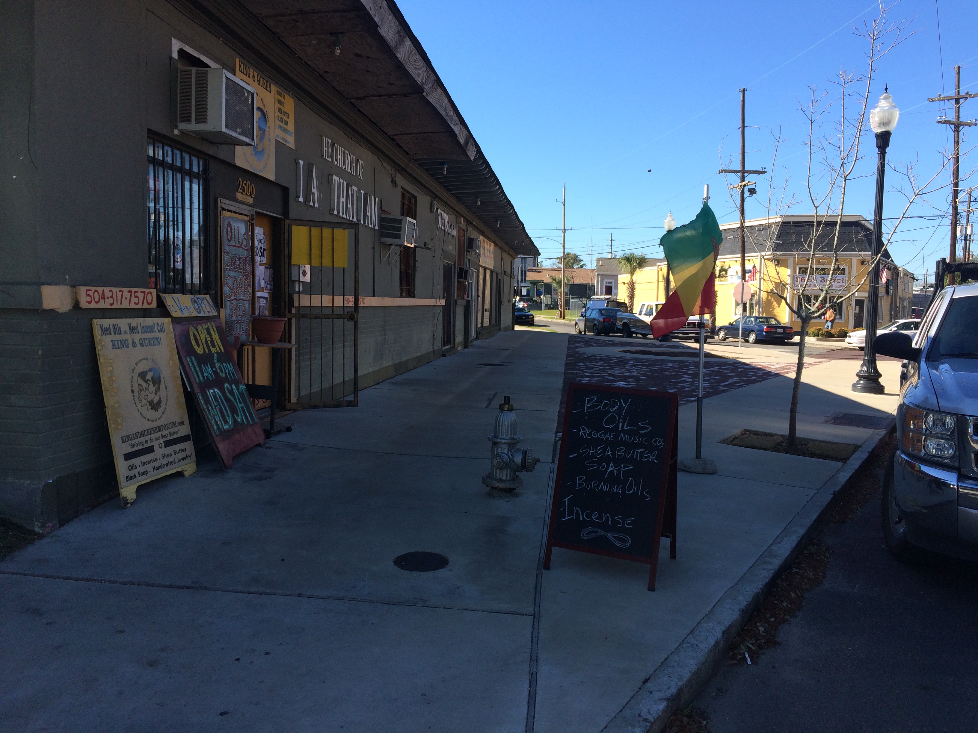
Alongside King and Queen Emporium Itn’l on Bayou Road, facing where Desoto breaks off to the left. photo by author

This bizarre intersection has everything to do with the odd-angled Bayou Road, “the road, trace, or portage [that] predated the city, following a narrow strip of high land that led from the Mississippi River past Bayou Sauvage, called Gentilly, to an intersection with Bayou St. John”[1]. Bayou Road was the thread, some argue, that made New Orleans possible—by lending the French a “backdoor route” from the Gulf through Lakes Borgne and Pontchartrain, down Bayou St. John, along the elevated ridge Bayou Road occupies to the Mississippi’s banks. The French could perch along the river’s edge, and thereby control the entire massive artery, without having to fight their way up its tumultuous mouth.

New Orleans Architecture explains that the corridor of “Bayou Road, on both its left and right sides, served as frontage for a series of concessions made first by the Company of the Indies, then by the kings of France, and later, the Spanish Crown. Simultaneously to the laying out of the city [ the present-day French Quarter]…these tracts of land to the rear of the city were developed into habitations (plantations) with houses and outbuildings facing each side of Bayou Road, having orchards behind and cultivated fields extending to the swamps” [2]. Even after the neighborhoods flanking Bayou Road were developed according to orthogonal street grids in the 19th century onward, Bayou Road was left to continue on its ancient, crooked way—there were too many houses and buildings already oriented along its trajectory.

So, back to my favorite intersection! Where, like, seven irregular triangles touch noses! The energy of the spot kept pulling me in, but until I did a little extra research in order to write this post, I didn’t realize how truly charged it was.…

It turns out N. Dorgenois Street formed the boundary line between some of these Bayou Road plantations that were continually changing hands throughout the city’s early history.

Chains of title can be kind of dull, but, in brief, between 1723 and 1834 the swath of land between N. Dorgenois and Bayou St. John (broken up into various parcels) was owned by folks with surnames like: Française, Langlois, Lebreton, Brasilier, Chalon, Almonester (the city’s wealthiest resident by the mid-1780s), Blanc, Vidal, Suarez, Clark, and Blanc again, until “…on September 26, 1836, Blanc sold to the Corporation of the City of New Orleans his ‘land or plantation, irregularly shaped having about twelve arpents frontage on Bayou St. John and bound by said Bayou, Carondelet Canal, Bayou Road, and Dorgenois…for $50,000’”[3].

Until around the time of the Louisiana Purchase, the particular sliver of land between N. Dorgenois and Broad was cultivated, but had no structures on it yet. Then comes Daniel Clark, Jr., the man who wanted to turn the land between the bayou and Dorgenois into Faubourg St. John. Historian Lawrence Powell tells us more about Clark: “…a young Philedelphian named Daniel Clark, Jr., Irish-born and Eton-educated, parlayed fluency in French and Spanish to become Governor Miró’s English translator, and then used that position to facilitate an illegal tobacco trade in which the governor silently partnered with Clark’s uncle, a wealthy Baton Rouge planter and New Orleans merchant. The younger Clark soon amassed a fortune from shipping and real estate, in the meantime joining the ranks of the slave-holding gentry”[4]. Later Powell tells us the two Daniel Clarks were some of the city’s largest slave-importers during the latter half of the 18th century.

Daniel Clark’s daughter, Myra Clark Gaines, stalled the development of Faubourg St. John after Clark’s death for close tosix decades via “the longest-running lawsuit in the history of the United States court system”(!!!) claiming she was the sole heir to his properties. (More on this fascinating lawsuit to come!) Before he died, Clark had succeeded in subdividing the faubourg into 35 irregularly-shaped blocks, however, and had envisioned the focal point of the neighborhood to be the fan-like formation of streets that inspired this blog post. New Orleans Architecture tells us that Clark built his country seat at the juncture of Bell, Desoto, and Bayou Road, roughly where King & Queen Emporium International is today. He died in the house in 1813 and it “ultimately fell into ruin and was demolished” [5].

So now we know a bit about the mainstream history of this tangle of streets in the 7th Ward. In my next post, I will seek to explore the little-known, less-recognized facets of this intersection’s history.…

1. Roulhac Toledano and Mary Louise Christovich, New Orleans Architecture Volume VI: Faubourg Tremé and the Bayou Road (Gretna: Pelican Publishing Company, 1980) xi.
2. Toledano and Christovich, New Orleans Architecture, xi.
3. Toledano and Christovich, New Orleans Architecture, 54-56.
4. Lawrence N. Powell, The Accidental City: Improvising New Orleans (Cambridge: Harvard University Press, 2012) 194.
5. Toledano and Christovich, New Orleans Architecture, 56.

LOAFING ROWDIES AND GOOSE RACES

This past New Year’s Eve, there was no shortage of conflict between revelers and police along Bayou St. John. I personally witnessed a city garbage truck chow down on a wooden barge that was to be set into the bayou near Magnolia Bridge and lit on fire—an extension, perhaps, of the debates over New Year’s Eve bonfires in Mid-City over the past decade.

The bayou, you may not be surprised to learn, has been the site of many “fringe rituals” over the centuries—as well as plenty of city-sanctioned recreational activities too, of course. New Orleans seems to specialize in these kinds of tensions; apparently we simply cannot resist the opportunity for a bit of fun, no matter the potential repercussions.…

In perusing the City Engineer’s Bridge Records from 1918-1967 this past summer, I found a letter from Walter Parker, Chairman of the Bayou St. John Improvement Association and future New Orleans mayor, to Honorable George Reyer, Superintendent of Police, dated April 10, 1934:

“It would help a great deal were some of your men to pass along the Bayou as frequently as practicable. Some boys who do not have bathing suits, do not hesitate to bathe in very scant underwear. At the Dumaine Street bridge many boys make the dangerous practice of climbing on the bridge structure. At the Magnolia Bridge (Harding Drive) boys dive from the top of the bridge pretty much all day. In so far as I know, people have a right to fish on the Bayou. But when they leave crab bait, old papers and remnants of lunch behind, they create a nuisance. I have found that such things usually are the result of thoughtlessness rather than viciousness, and a simple request or word of warning brings a correction….” [1]

Many of you have probably heard about the annual St. John’s Eve voodoo ceremony that takes place on the Magnolia Bridge every June 23rd. Bayou historian Edna Freiberg explains that after the Haitian Revolution, New Orleans authorities began to get jittery about potential slave uprisings in their own city. On October 15, 1817, City Council forbid people of color from congregating in large groups “except in times and places specified by authorities.” [2]

Following this mandate, voodoo rituals moved to the untamed upper bayou, along the shores of Lake Pontchartrain, where the authorities wouldn’t be as likely to quash them. The voodoo rituals performed on the bayou today may be an extension of these religious ceremonies pushed to the fringe by the powers that be. (More on this when I conduct in-depth research on the subject.)

Aside from the recreational pursuits of the New Orleans elite in the 19th and early 20th centuries (rowing races for which thousands of finely-dressed spectators turned out during the summer months; picnics at Magnolia Gardens, where visitors could purchase beer and ice cream; sketching parties on the bayou’s banks; a “young ladies rowing club,” complete with “costumes” and “chaperones”; and “pleasure drives” along the shell road to Lake Pontchartrain, to name a few), neither was there a shortage of ad hoc recreational events along the bayou during those years, some deemed more acceptable than others.

Readers may remember a “strange duel” I mentioned in a previous post, for example.

Or take this Times-Picayune piece from June 20, 1872, in which a set of “loafing rowdies” are up to no good: “The attention of the police is called to the fact there is a crowd of men who daily congregate on or about the bridge over Bayou St. John and demean themselves most disgracefully. They appear to find especial pleasure in making use of the vilest sort of language, yelling, singing unchaste songs, and insulting persons whose necessities carry them in that direction. This sort of thing has grown to be an intolerable nuisance, and should be abated at once. Bayou St. John is one of our most popular afternoon promenades during the heated term, and the ladies and gentlemen who seek recreation and pleasure at that point are entitled to a share of police protection from the misconduct of loafing rowdies. It is suggested that one or more officers be stationed near the bridge, day and night, as the services of the police are very often needed by the residents in the neighborhood.”[3]

And one of my favorite examples, from 1876: “A goose race is proposed to come off at Bayou St. John next Sunday. There will be several contestants, each in his tub, which will be drawn upon the water by six geese. There distance will be one hundred yards.”[4] Does anyone else feel like a hundred yards is actually pretty far to travel via goose-drawn tub?

Or an example of the kind of entertainment one might hope to find on a summer’s day at Spanish Fort: “Prof. Clark, the renowned swimmer, appears again this evening and to-morrow in a series of difficult feats on water at the lake end of Bayou St. John. This novel exhibition is to include eating, drinking, and writing under water; also a military drill by the skillful Professor. To the end of providing for the many going, the cars of the City Park and Lake Railroad will run every half hour without fail.”[5]

Lastly, although this is a bit of a stretch, I wanted to include the strange recreational habits of a Mrs. Taylor Shatford, who lived for a time on Bayou St. John: “It was in 1916, after a trip abroad, that Mrs. Shatford became convinced that she was controlled by the spirit of Shakespeare. Operating with a ouija board she began to take dictation from him, and later declared she had trained her psychic senses…and could actually hear the words from his ghostly lips.”

The article provides us with a snippet of The Bard’s genius-beyond-the-grave, via Shatford’s ouija board: “‘We carry here the man we were. Our longings, like, some hatreds as of yore. And I who wove my rhyme am he, the same, except for my soul’s tears. To all who yearn to know if still man lives without his bones I say Complete. He dies never. His ashes are remnants of his suit. I have my whiskers still.”[6]

See?! Even the long-dead William Shakespeare can’t resist shenanigans the bayou every now and again!

1. New Orleans City Engineer’s Bridge Records, 1918-1967, City Archives Louisiana Division, New Orleans Public Library
2. Freiberg, Edna B., Bayou St. John in Colonial Louisiana 1699-1803. (New Orleans: Harvey Press, 1980) 294.
3. “The City. Public Hacks and Hack Drivers. Their Condition And Future Prospects.” Times-Picayune 20 Jun. 1872: 2. NewsBank. Web. 13 Jan. 2016.
4. “City Gossip.” Times-Picayune 29 May 1876: 2. NewsBank. Web. 13 Jan. 2016.

5. “Aquatics At Spanish Fort.” Times-Picayune 14 Jul. 1876: 1. NewsBank. Web. 13 Jan. 2016.
6. “Spirit Of Shakespeare Works Through Medium Revelations of Poet Made in New Orleans to “Medium.” Times-Picayune 11 Jan. 1920, |: 33. NewsBank. Web. 13 Jan. 2016.

THE SPANISH FORT AND ITS MANY HATS

In learning recently of a 2013 archaeological dig at the colloquially termed “Spanish Fort” site on Bayou St. John, my fascination with this spot was renewed. The dig, conducted by FEMA, revealed a Native American shell midden peppered with fragments of animal bones, pottery, clay pipes, and other artifacts dating from the late Marksville period, from around 1,600-1,700 years ago.

Instead of destroying it entirely, as early colonial accounts had suggested they’d done, the French simply sliced off the top of the midden and used it as a foundation for the wooden fort they built there in 1701. The Spanish then reinforced the fort in the latter half of the 18th century, and the Americans reinforced it still further in 1808.

Although the fort never saw much military action, the piece of land it sits on has seen an astounding amount of human activity over the past 2,000 years. Throughout much of the 19th century, the site was a popular spot for picnics and swimming, boasting a resort hotel catering to New Orleans elite looking to escape the city and spend an afternoon on the shores of Lake Pontchartrain.

After a fire destroyed the hotel in 1906, the New Orleans Railway and Light Company built an amusement park that drew New Orleanians to the site by the thousands. By the 1920s, activity at that crook of land between Bayou St. John and the lake began to decline when the Orleans Levee Board began their extensive Lakefront Project, “reclaiming” land from the lake in Orleans Parish and fortifying it with a sea wall.

That’s a lot of activity for one small slip of bayou bank! The site has “worn many hats,” you might say—first a shell midden hat, then three different kinds of fort hats, then a hotel hat, then an amusement park hat…. What a stylish and versatile hunk of mud! Such elaborate head-pieces!

What follows are some quotations and photographic snippets of these many layers of Spanish Fort history.

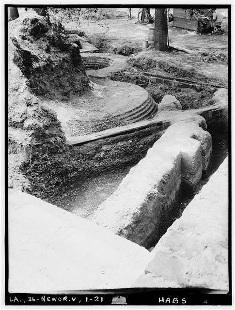
From the Library of Congress, a 1934 photo taken as part of the Historic American Buildings Survey. Look at all those layers of fort!

A notice posted by Louis Lacuna & Co. in the July 4, 1841 Times-Picayune:

The fine Hotel at the Lake end of the Bayou St. John is now ready for the reception of visitors, having every variety for amusement—Billiards, pistol shooting, bathing, &c. The Restaurant is furnished with the best the markets afford.”[1]

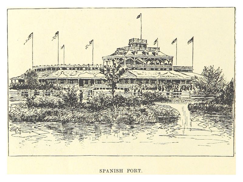
From Wikimedia Commons, a circa 1883 drawing of the Spanish Fort by Mark Twain (!) from his book Life on the Mississippi.

From a book written by Eliza Ripley, called Social Life in Old New Orleans, published in 1912, we have a description of the “Lake End” resort and what its fine dinners can do for a person’s femininity:

“There was a large hotel (there may be still—it is sixty years since I saw it), mostly consisting of spacious verandas, up and down and all around, at the lake end of the shell road, where parties could have a fish dinner and enjoy the salt breezes….The old shell road was a long drive, Bayou St. John on one side, swamps on the other, green with rushes and palmetto, clothed with the gay flowers of the swamp flag. The road terminated at Lake Pontchartrain, and there the restful piazza and a well-served dinner refreshed the inner woman.”[2]

(In reading this, I can’t help but wonder if that shell road was paved with shells dredged from the midden at the Spanish Fort site….)

On December 30, 1913, the Times-Picayune ran a full-page ad for New Orleans Railway and Light Co., in which the new amusement park was mentioned:

“SPANISH FORT: A historical spot situated on the lake shore at the junction of Bayou St. John. A delightful resort, operated in summer with music, vaudeville and light opera. Full of romantic reminiscence,—a beautiful spot, shaded with an abundance of trees and other shelters. In the summer there are many attractions, various amusement devices, restaurants, casinos, and ice cream parlors. An excellent electric train service from Canal and South Rampart St.”[3]

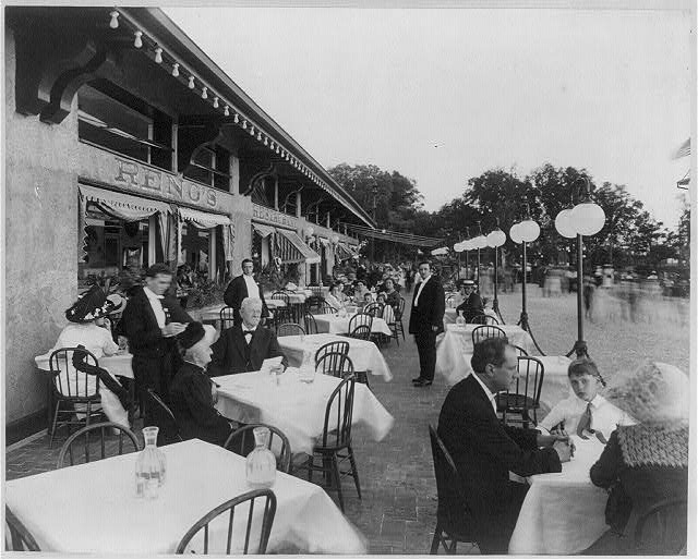
Some Spanish Fort diners in a Library of Congress photo titled “Afternoon scene of Reno’s Restaurant,” dated May 27, 1912. I love being able to see the movement of passersby just off the patio to the right….

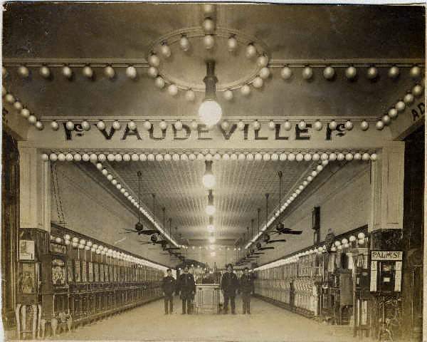
From Wikimedia Commons: “‘Fitchenberg’s Penny Arcade’ at Spanish Fort amusement park, New Orleans, circa 1910,” photo by John Norris Teunisson.

Lastly, a rollicking description of the Spanish Fort amusement park in its later years from the Times-Picayune, June 8, 1924:

“NEW RECORD MADE AT SPANISH FORT—Popular Lake Resort Reports Heaviest Attendance in Its History—The last week witnesses a new record for crowds at Spanish Fort amusement park. Despite the rain thousands of Orleanians attended the dances at Tokio Gardens and made a round of the various amusements and concessions, including the Giant Dipper, the Dodgem, the Whip, the Caterpillar, the Merry-Go-Round, the Penny-Arcade and other attractions. As usual Emile Tosso and his concert band drew a heavy patronage….Tokio Gardens continues to be the center of attraction of the younger dancing set of the city, and any night until midnight hundreds of dancers attend. Of all the thrilling attractions at the park, the Giant Dipper seems to have the most appeal. The thriller is a mile long and is negotiated at the rapid speed of 57 seconds. Second in popularity is the Dodgem, which has all the excitement of a railroad wreck with none of the dangers. The Whip, next in choice of the crowds, is the famous ride first established at Coney Island. The Caterpillar is especially popular with young couples. It consists of riding under cover in the dark at a rapid speed in an artificial cyclone.…With the increase in temperatures many persons are finding relaxation at Tranchina’s bathing pavilion where all facilities for an enjoyable swim are at hand, including dressing rooms, towels, lockers, bathing suits and other equipment, such as slides and chutes of the finest type.…”[4]

Shooting through the darkness with one’s sweetheart “at a rapid speed”—that Caterpillar sounds positively scandalous!

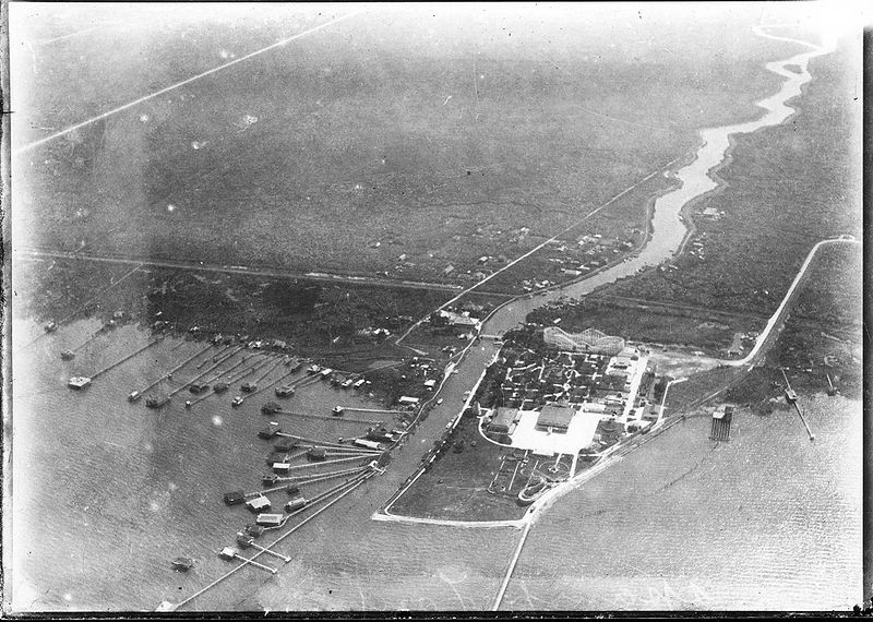
From Wikimedia Commons, before the Lakefront Project extended the lake shore: “Aerial photograph of Spanish Fort Amusement Park, New Orleans, 1922. Showing intersection of Bayou St. John and Lake Pontchartrain, “camp” houses on piers in the shallows of the lake, and undeveloped (pasture) land to the south.”

There are many mysteries associated with the Spanish Fort that I didn’t get into today—like the unmarked grave enclosed by an iron fence at the site, or the unidentified Civil War submarine that was hoisted from the bottom of the bayou next to the fort over a century ago, now housed in the Louisiana State Museum in Baton Rouge, or the strange rock sculptures that may be associated with the amusement park of yesteryear still visible to those driving by….

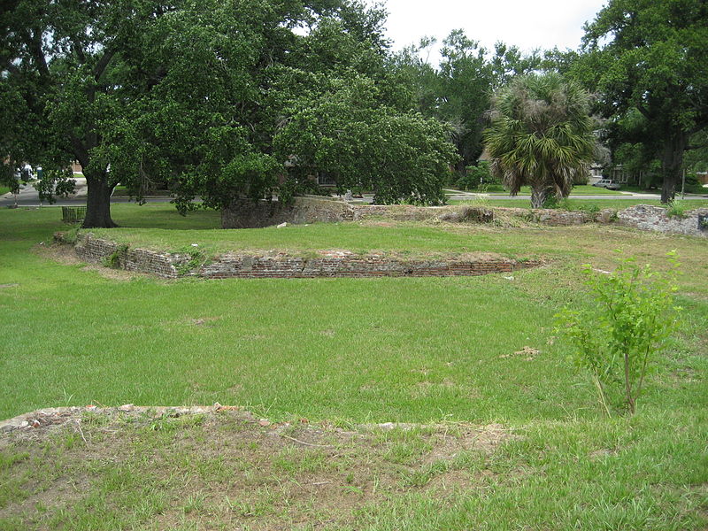
If this doesn’t inspire you to visit the quiet, unassuming Spanish Fort ruins of today—in order to imagine the waves of activity the site has witnessed over the years—then I don’t know what will!

1. Times-Picayune 4 Jul. 1841: 3. NewsBank. Web. 16 Dec. 2015.
2. Ripley, Eliza Moore Chinn McHatten,Social Life in Old New Orleans, Being Recollections of My Girlhood.(New York; London: D. Appleton and Company, 1912) 63.
3. Times-Picayune 30 Dec. 1913: 24. NewsBank. Web. 16 Dec. 2015.
4. Times-Picayune 8 Jun. 1924: 67. NewsBank. Web. 16 Dec. 2015.

A LOVE LETTER TO LAKE PONTCHARTRAIN

Lake Pontchartrain, I’ve underestimated you. Or at least largely ignored you while I’ve lived in New Orleans—and you know what, it’s my loss. There’s something somewhat static or expected about the idea of a lake. Many of the lakes in Maine, where I’m from, could very well have more interesting hydrologic histories than I was ever aware of growing up (ancient freshwater trapped in glacial scars, no doubt), but for the most part, I tend to think of lakes as bodies of water with relatively low variability. Large puddles, essentially, that one can take a kayak or a rope swing to. Primarily unchanging, potentially polluted (not naming any names), and probably mucky on the bottom.

Lake Pontchartrain, none of these things describe you! You are technically a lake, if a lake is defined as a body of water surrounded by land, but that is definitely not the best term for you. No, you are an estuary, one of the most productive types of ecosystems on the planet, thank you very much. Until recently, I thought an estuary was simply any brackish body of water—and that still may be true—but a more accurate definition of an estuary is the place where a river meets the sea, where freshwater and saltwater swirl together. That liminal place where a river is in the process ofarriving. Maybe many of you readers already knew this about Lake Pontchartrain—but I didn’t, so bear with me!

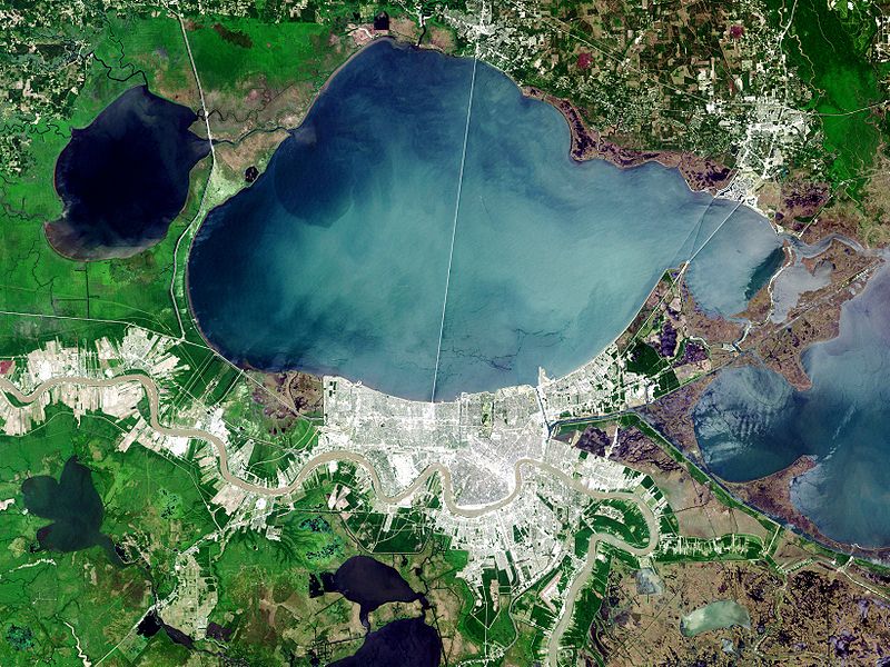
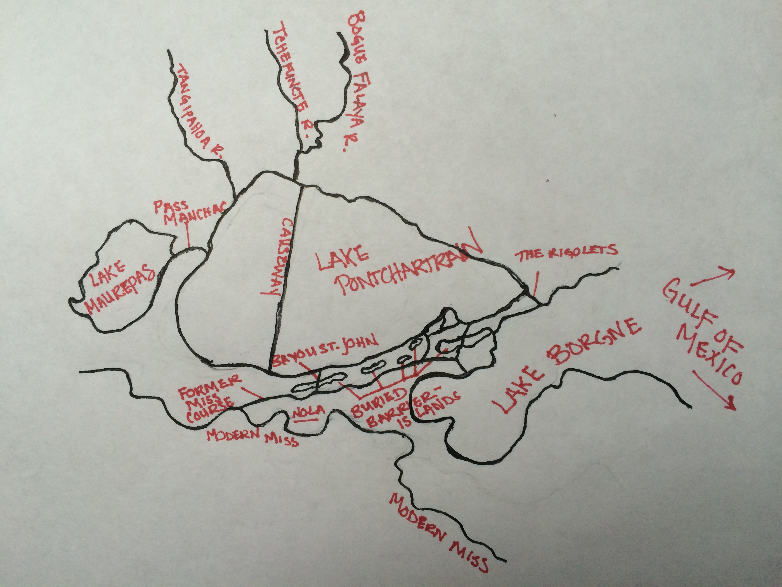
As I’ve described in a previous post, Lake Pontchartrain was formed a few thousand years ago by the interplay between a swinging arm of the Mississippi River (before it landed in its modern channel) and a relict, now-buried barrier-island chain that swoops along its southern border like a pearl necklace. Although that former Mississippi wanted to swing north, toward the center of the present-day lake, the sandy island chain prevented it from doing so and it was forced to continue on its northeastern trajectory, forming an oval of earth-trapped seawater in the process. It would have sealed off the lake altogether, but it turns out the Mississippi wasn’t the only river in town. What about the TangipahoaTchefuncte, and Bogue Falaya rivers, coursing into the lake from the north (badass rivers in their own right, boasting rich Native American histories)? They continued to empty their insides into our friend LP, and the water had to go somewhere! A river, no matter how small, must always make its way to the sea. The freshwater forced its way through the eastern edge of the lake, eventually forming the Rigolets and allowing salt water to enter in and out when it pleased. So, to say this another way: Lake Pontchartrain serves as an estuary for three very respectable rivers. When’s the last time you could claim anything nearly as cool?

Lake Pontchartrain, you aren’t just connected to those Northshore rivers and the Gulf via the Rigolets, however. You connect to the Gulf via the Chef Menteur Pass, too, and Lake Maurepas via Pass Manchac. Now you even touch the modern Mississippi herself—via the Bonnet Carre Spillway and the Industrial Canal. And, since 2014, you connect to the Bayou St. John again! The metal door that had been shut tight between you for decades is now open, at least intermittently. You remind me of a broad, shallow heart, pumping water—salty and fresh—in and out of your various pathways and conduits, continuously.

You’re a bit under the weather though, I should mention. Your wetlands are sediment- and freshwater-starved. You’re suffering, as this whole region is, from a lack of Miss River nutrients. It wasn’t always this way.

Lake Pontchartrain fun-facts:

LP touches six Louisiana parishes! St. Tammany, Orleans, Jefferson, St. John the Baptist, St. Charles, and Tangipahoa.

Its average depth is only 12-14 feet!

Its bridge, the Lake Pontchartrain Causeway, is the longest (continuous) bridge over water in the world, according to the Guinness Book of World Records. It’s also featured in this 1988 ode to New Orleans, by Lucinda Williams, which is what I will leave you with….

BONE BEDS AND BACKSWAMP

First of all, I want to thank ViaNolaVie​ for including my bayou blog posts on their site going forward! I am honored to be presented alongside the stories of exceptional quality NolaVie consistently offers on life and culture in our fair city. I will be writing, from here on out, bi-weekly posts on what I’ve been learning while researching the history of the Bayou St. John—“field notes,” if you will—much as I’ve been doing over the past few months.

This week, I will be talking about Native American shell middens again—because they’re so incredibly cool, and because, as I learn more about the prehistory of our area, I’ve come to realize shell middens are even cooler than I initially thought….

Because, here’s the thing: we know so few specifics about Native American life in this particular region before the end of the 17th century. Between when the first European “explorers” traveled up the Mississippi in the mid-16th century and the second wave of “explorers” came to the region more than one hundred year later, European-borne diseases had already ravaged the local Native American population. For reasons we aren’t entirely sure of—intertribal warfare, and/or other consequences of French arrival—tribes were moving around incredibly quickly, and generally changing their habitation and subsistence patterns in drastic ways by 1699. But accounts by these later European explorers are the only written descriptions we have to go on: questionable vocabulary, snippets of detail about post-contact native life, and virtually nothing reliable on pre-contact native life at all. We can learn a lot from archaeological evidence, of course, but most of that has been destroyed in the New Orleans area. So, we are left to imagine….

and talk about shell middens.…

and look at the patterns that emerge when we consider the landscape. Those of us in New Orleans happen to live upon a very unique and dynamic landscape. A landscape with very specific resources and challenges—an example of what happens when an alluvial river (the Mississippi) sweeps its arm out and encloses a little circle of the sea (Lake Pontchartrain). Obviously it’s a bit more complicated than that, but my point is we live in what they call a “deltaic coastal” natural system: Lake Pontchartrain is an estuarine ecosystem, thought to be one of the richest and most diverse kinds of ecosystems on the planet, and, until we “tamed” the Mississippi, the land along and below Lake Pontchartrain was constantly moving and changing according to the river’s proximity. By considering the natural system we live in, in combination with the archaeological evidence we find here, we can make certain broad (very un-nuanced) guesses about Native American movements and subsistence habits in the region.[1]

I’m still trying to get a grasp on the different fields that explore the intersection between human history and landscape (geoarchaeology and historical ecology, to name a couple): the vocabulary used by scholars in those fields, how the fields have grown and changed over time, etc. But my heart was pounding with excitement reading an essay called “Geoarchaeology of the Northern Gulf Shore,” by Sherwood M. Gagliano. In it, one finds terms like:

“man-land relationships”

“bone beds”

“Holocene still stand”

“subsided site situations”

“drowned river valleys”

“cascades of energy”

and “fringing backswamp”[2]

Among many other things, we learn from Gagliano what it means when archaeological deposits are found on top of (vs. “interbedded” into, or foundbehin​d) natural levee surfaces: the deposits must have “accumulated after the distributary had been abandoned as an active course of the parent stream.” [3]

Meaning, when we find a shell midden on top of a ridge that was formed by a former path of the Mississippi (as in, shell middens found on the Metairie-Gentilly Ridge, for example, near the bayou), we learn that people must have lived on this ridge once it had fully matured. Meaning, Native Americans probably utilized the high ground of the ridge after the Mississippi had already swung south, leaving a mere trickle of itself behind. This trickle would have been perfect though! It would have been a great means of transportation to the overland portage that led to the current trunk of the Mississippi River, as well as to the mollusk-strewn shores of Lake Pontchartrain. The ridge would have allowed access to both brackish and fresh water, but wouldn’t have presented much of a flood risk. Also, the archaeological site that was discovered (more details to come) near where the bayou meets Lake Pontchartrain would have been an ideal coastal location as well.

If most of the middens in the area around the bayou are gone now, however, how are we sure they were ever there? Well, for one thing, we have some folks from yesteryear who tell us about them, like this guy, John W. Foster, writing in 1874:

“These shell ridges and occasional mounds are very numerous near the city of New Orleans and along Lakes Pontchartrain and Maurepas, and on the small bayous that pass from one into the other….Shell-mounds and shell accumulations abound along the Metairie, the Gentilly, and the lake-shores, but none along the Mississippi…. Along the banks of [Bayou Barataria] are vast shell accumulations, which for years, like the others I have named, have been used for street grading and garden-walks in New Orleans….this trade is fast exhausting these supplies.”[4]

There ya go. For years, Metairie Road was called “The Shell Road,” or “The New Shell Road,” and was paved with white clam shells quickly turning to dust beneath mule hooves and wagon wheels. They were probably the remains of shell middens, shoveled and dispersed and made smooth. (In more recent times, we dredged shells from Lake Pontchartrain for construction purposes, so not all the shells you see scattered about New Orleans are from middens, alas).

Ok—last but not least—the highlight of the last couple weeks:Jean Lafitte National Park, located south of New Orleans in the Barataria Preserve. Although I’ve been there a few times before, here is what I discovered on my most wonderful last visit:

Baby sunglasses nestled between palmetto fronds.

Cypress swamp.

Awater-hyacinth-choked manmade canal (water hyacinth is an invasive species that also clogged Bayou St. John in the 20th century). Can you spot the white building looming at the end of it? This photo was taken my pressing my iPhone against the eye piece of high-quality binoculars.

A baby alligator (can you spot it??).

Another baby alligator.

A cypress tree somewhere around 200 years old, spared (for some unknown reason) by loggers when they came through and harvested almost every cypress tree in the swamp in the 19th century.

The remains of a giant shell midden! One of the ones our friend John W. Foster mentioned in the paragraph above (“along the banks of Bayou Barataria”)!

The plaque tells us more:

I’m still pondering the importance of that oak tree. I understand that it grew on top of the midden, and then when the midden was hauled away, the oak tree stayed in place. But the oak tree was virtually alone among cypresses and other swampy flora. I’ve since learned that the state park is near (or encompasses?) another former Mississippi River course (more details when I’ve learned more) and is therefore similar in elevation to our Metairie-Gentilly ridge—and therefore has the proper soil and drainage for hardwood trees, like live oaks, to grow. But I’ve also been reading more by Tristram R. Kidder, who I talked about in my last post, and he posits a theory about shell middens actually creating their own mini ecosystems, resulting in species of flora that wouldn’t otherwise be growing there. He even throws out a theory about Native Americans actually purposefully building middens as artificial environments (as opposed to their being merely garbage heaps)—built environments that would provide elevation, as well as nutrients to calciphiles (plants that like calcium-rich soil) or other useful plants that otherwise might not grow in the area….[5]

I have much still to learn on these subjects. Don’t worry—I’ll keep you in the loop!

1. Sherwood M. Gagliano, “Geoarchaeology of the Northern Gulf Coast,” Perspectives on Gulf Coast Prehistory, ed. Dave D. Davis (Gainesville: University of Florida Press/Florida State Museum, 1984) 9; 25.
2. Gagliano, “Geoarchaeology of the Northern Gulf Coast.”
3. Gagliano, “Geoarchaeology of the Northern Gulf Coast,” 28.
4. John W. Foster, Pre-Historic Races of the United States of America. (Chicago: S. C. Griggs, 1874) 157-158.
5. Tristram R. Kidder, “The Rat That Ate Louisiana: Aspects of Historical Ecology in the Mississippi River Delta,” Advances in Historical Ecology, ed. William M. Balee (New York: Columbia University Press, 1998) 157-160.

CLAM SHELLS AND WHITE MAN PRATTLE

In a fluid, rockless, ever-shifting landscape—formed by the warring forces of sediment accretion and subsidence—elevation is everything.

This week, I learned about two interesting ways in which Native American involvement in matters of elevation affected the landscape of New Orleans.

Tristram R. Kidder, in his essay “Making the City Inevitable: Native Americans and the Geography of New Orleans,” talks about the idea of the “Ecologically Noble Savage.” Western thought, until perhaps recently, has consistently underestimated the ways in which Native American habits and movements affected the landscape. America, before the arrival of European colonists, was widely seen as a vast, unconquerable wilderness with which indigenous peoples lived “in harmony,” tiptoeing through the forest shooting silent arrows, leaving barely a trace. Europeans, by contrast, tamed the beast—for better or for worse.[1] However, Kidder writes, “Ecological transformations [by Native Americans] may not be quantitatively the same as those in recent times, but qualitatively they are no less real or meaningful.” [2]

One of the most notable ways Native Americans altered the local landscape (primarily the marshy parts) is through shell middens—those semi-intentional garbage heaps filled with discarded animal bones and clam shells. These raised mounds “form an entirely new ecozone in the marsh” resulting in much higher ecological diversity, even in modern times.[3]Perhaps one of the best examples of these midden-ecozones in our area is in New Orleans East, where archaeological sites near Lake Pontchartrain have resulted in stands of live oak, cypress, hackberry, and willows trees in an otherwise entirely flat brackish expanse.Kidder also mentions shell middens once found along the Metairie-Gentilly ridge (site of our beloved bayou), the shells of which were later excavated for paving roads and making lime. Unfortunately, Indian sites in the vicinity of the bayou have been largely destroyed by these kinds of excavations in the 18th century, or else by the urban expansion that characterized the 20th. [4]

Perhaps the most important way in which Native Americans impacted the local landscape, however, was by showing French colonists the portage route, employing Bayou St. John, from Lake Pontchartrain to the Mississippi River—a communication that resulted in the founding of New Orleans in its present location (although there were a few other factors that went into this decision). Archaeological remains near where the bayou meets the lake prove that native people were aware of this route (if Iberville’s diary entries aren’t further proof!). Although confusion abounds as to which specific tribes lived in the vicinity of the bayou, particularly since, by the time Iberville floated into the area, much of the native population had been killed off by disease or had relocated for other reasons (not to mention recording errors!), there is no doubt their communication with Iberville regarding the portage was absolutely critical. [5]

Kidder writes, “The extension of native knowledge to European contexts is what makes Bayou St. John both a tangible image and a metaphor of the historical transformation of New Orleans.” [6] Bam.

Now, as a foil to these facts, I wish to present you with a humorous (if only because it’s so confidently asinine) window into the Mind of the New Orleans White Man, circa 1845, courtesy of the Historic Times-Picayune. Of course, it’s funny but it’s also despicable and depressing as hell.

“Lo! THE POOR INDIAN. — A few—some dozen or two—of the once powerful tribe of the Choctaw Indians, still hang about the purlieus of this city, in the neighborhood of the Bayou St. John. Near Clark’s house, at the Bayou Road, where once blazed the council fire of their sachems, now burn their cooking fires, and the smoke of their miserable huts supplies the place of the smoke of the calumet—they wander about like ghosts of departed greatness. Periodically they serenade the citizens, when they turn out in all the remaining strength of the tribe—men, women and children. On these occasions a long, bare-legged fellow beats an apology for the Indian drum; another fellow goes about, levying contributions; and the remainder, in concert, sing a kind of guttural chorus, resembling a ventriloquist’s imitation of a wood-sawyer at work. These levies are always made under the pretense that there has been a wedding in the tribe, and that the funds solicited are raised for its due celebration. Now if this be the case, we can only say that celibacy is a state of existence unknown to the Choctaws—nay, that bigamy is recognized among the tribe to the fullest extent; for we will be sworn that seven times seven within the last seven years have we seen every squaw in this remnant of the tribe, who could at all assume the character, play on these occasions the part of the bride. The whole thing, we take it, is but a way they have ‘raising the wind,’ to have ablow-out, and perhaps this device is as harmless a one as they could adopt. These remarks were suggested by seeing them going the rounds yesterday—all paint and prattle as usual.” [7]

1. Tristram R. Kidder, “Making the City Inevitable: Native Americans and the Geography of New Orleans,”Transforming New Orleans and Its Environs: Centuries of Change, ed. Craig E. Colten (Pittsburgh: University of Pittsburgh Press, 2000) 9.
2. Kidder, “Making the City Inevitable: Native Americans and the Geography of New Orleans,” 20.
3. Kidder, “Making the City Inevitable: Native Americans and the Geography of New Orleans,” 13.
4. Kidder, “Making the City Inevitable: Native Americans and the Geography of New Orleans,”14; 16; 19.
5. Kidder, “Making the City Inevitable: Native Americans and the Geography of New Orleans,” 17; 19.
6. Kidder, “Making the City Inevitable: Native Americans and the Geography of New Orleans,” 20.
7. “Lo! The Poor Indian.” Times-Picayune 26 Jan. 1845: 2. NewsBank. Web. 8 Oct. 2015.

FLUNG ROSES AND STOPLIGHT GRAVEYARDS

After a long hiatus, bayou posts are back! I know you’ve been waiting on tenterhooks….

After four months of more general Bayou St. John research, I am about to start focused research for the first chapter of the book—on the bayou’s geomorphic/geographic and Native American history. If anyone has any advice for me—ideas for what to read, who to talk to, etc.—reach out! I get to talk about former Mississippi River pathways, sediment deposits, pirogues, trade routes, slight-but-significant ridges.… CAN’T WAIT.

The past couple weeks, I’ve been on a few bayou adventures.

I biked the almost-100%-completed Lafitte Greenway—a 2.6-mile bicycle and pedestrian trail extending from N. Alexander St., near the base of City Park, to the French Quarter.

New Orleans residents may or may not realize that the Lafitte Greenway follows the path of the former Carondelet Canal, a waterway hand-dug by slaves in the late 18th century, when New Orleans was still under Spanish control, and utilized throughout the 19th century as a commercial conduit between the bayou and the French Quarter. This meant ships laden with goods from settlements north of Lake Pontchartrain or along the Gulf could avoid navigating the Mississippi River altogether and travel through Lake Pontchartrain, down Bayou St. John and into the Carondelet Canal in order to off-load their goods at the rear of the French Quarter.

A vew of the Lafitte Greenway between the bayou and Broad St.

If you ever wondered where old New Orleans stoplights ended up….

The open canal that runs between Broad Street and the bayou, positively gushing as it exits the Broad St. pumping station. Doesn’t it look almost turquoise? Don’t let that fool you. It stinks.

The giant locks at the Broad St. pumping station that control whether water flows up the underground culvert beneath Broad St., or else out to the Orleans outfall canal, via the open canal along the greenway.

There is much more I could (and WILL, in the book) say about the Carondelet Canal. But for now: there is a fabulous (free!) exhibit at the Pitot House on the history of the Carondelet Canal, curated by the Louisiana Landmarks Society, in celebration of the opening of the Lafitte Greenway. So many beautiful old maps and photographs!!! It is both succinct and intensely interesting. I HIGHLY recommend it.

After biking the greenway, I checked out the historic Ossorno House in the Quarter, at 913 Governor Nicholls.

This house was built on the Bayou St. John sometime before 1781 and apparently dismantled and transported, most likely via mule and cart, along Bayou Road to its present location—as were all goods traveling from the bayou to the Quarter before the Carondelet Canal was dug. According to geographic historian Richard Campanella (one of my heroes), in his Geographies of New Orleans: Urban Fabrics Before the Storm, the house is a fine example of a French Creole-style plantation house (although the roof was remodeled sometime in the 1830s)—one of only two plantation-style houses to be found in the French Quarter (the other being Madame John’s Legacy)—which testifies to its rural birth on the bayou. Campanella tells us it’s “the oldest extant structure in the rear of the original city” (106).

I then decided to bike the approximate path of this all-important route along Bayou Road, one of the principal reasons why New Orleans was founded where it was (for access to the river without having to navigate its mouth, as was mentioned above).

In traveling along the (approximate) portage route, one follows Bayou Road, which ends at the crazy, navigationally-nightmarish, odd-angled intersection of Bayou Road, N. Dorgenois, Desoto, Bell, and Kerlerec streets (thank god there’s delicious food right there, at Pagoda Cafe, for the weary, confused traveler) and continues along Bell Street (approximately) to the bayou. The exact location of the original route’s intersection with the bayou was probably somewhere between Bell St. and Desoto (more on this once I continue more in-depth research on the subject).

This terrible panoramic photo (thanks iPhone!) taken from next to Pagoda Cafe, while inaccurate in perspective, I think does justice to the psychological experience of navigating this intersection….

While in this neighborhood, I found…

A historic cornstalk fence at the historic (1870) Dufour-Plassan House.

The approximate general region where Almonaster built a leper hospital in the late 18th century.

An awkward spot where Barracks Street and Bayou Road diverge at a bizarre angle, since Bayou Road does not adhere to the grid plan the rest of the streets in the area adhere to—following, as it does, a natural ridge, the one the Native Americans used to cross the uncrossable swamp between the bayou and what is now the French Quarter.

Finally, I arrived at the bayou itself. Here are a few spots of interest along its banks, a couple of which I was lucky enough to get to go inside of (!!), courtesy of the generous, unsuspecting homeowners I found busying themselves in their front yards.

The house, at 1222 Moss Street, that sits atop what was once a small bayou connecting Bayou St. John and Bayou Sauvage, long since filled in.

What is referred to as “the old Spanish custom house,” although it never officially served as a custom house (there are various theories as to why people refer to it as such). I was lucky enough to get an in-depth tour of the inside of this home (!!!), the owner of which has been painstakingly renovating it for six years. Beneath layers and layers of renovations that have been done over the past two and a half centuries, he has made some amazing discoveries—like anactual iron jail cell, apparently dating from the Spanish colonial period, that the current owner suspects was used to hold folks who were smuggling illegal goods up the bayou, or who perhaps couldn’t pay the toll. ARE YOU KIDDING THAT’S AMAZING.

Below is the plaque that explains a bit more about the house.


Roses that someone had flung into the bayou near the Magnolia Bridge.

And, last but certainly not least, what is perhaps my favorite historic house along the bayou, built in the last decade of the 18th century: “The Sanctuary.” Walter Parker, former mayor of New Orleans, who spearheaded the “beautification” of the bayou in the 1920s and 1930s and who is therefore responsible, in large part, for the bayou as we know it today, once lived in this house. I wasalsolucky enough to be able to see the back courtyard of this home—guarded by a three-hundred-year-old live oak tree that predates the house, and other amazing, old, beautiful things. More on this house, and its many previous owners, to come.

BAYOU BEAVER TAKEN ON JOYRIDE

It’s not surprising that in researching historic New Orleans through the lens of its most prominent newspaper, one doesn’t hear about women very much. Or people of color, except when reporters describe their causing a “nuisance,” or their “savage” Voodoo ceremonies in the backswamp along Lake Pontchartrain.…

Really, though. One almost forgets that one hasn’t heard mention of a single female human for the past several hours of research until one pops up, usually in the form of a bayou drowning-victim, or a recent widow of a prominent man, or a woman of “ill refute.”

Sometimes, your eyes get tricked! A “she” or a “her” will pop out of the text, but it’s only in reference to a motorboat or a schooner….

Which got me thinking about the concept of gendering inanimate objects. Why are boats saddled with feminine pronouns, and often cities too? (This once struck me as kind of quaint.) Boats are built and tricked out and ridden to get from place to place—by men exclusively, or at least they used to be. They are used to make money, or are status symbols themselves. They’re often slender and sleek, but that’s probably just a coincidence. Cities were built and planned and operated by men too—and in many ways, they still are.

Here is a 1913 Times-Picayune article from my travels this past week that, aside from being comical, echoes in interesting ways the ideas above:

“PIRACY IS CHARGED.

Charges of piracy and the wanton violation of the maritime laws of the United States are alleged in a libel and complaint personam filed in the United States District Court yesterday against Frederick W. Smith, 2906 St. Ann Street. The complainants in the case are Harry Oldstein, Morris Wise, Henry D. Friedenberg and Arthur Schmidt, owners of the gasoline motor-boat Beaver, who charge the defendant with having illegally taken possession of the vessel on June 24 last, while the boat was lying in the Bayou St. John, and sailed out to Lake Pontchartrain with a party of women on a joy ride. Libelants declare that their yacht was stocked with intoxicating liquors by the defendant, who, after breaking the headline to which she was made fast to the wharf, placed a party of women of ill-fame on board and steamed out to the lake, where all had been guilty of lewd conduct, to the great humiliation, ridicule and contempt of the owners. Damages are asked in the sum of $1,650.” [1]

She, the Beaver, was taken possession of—was freed from her tether, stocked with booze and floozies, and taken on a joy ride. The men who own her are pissed—their property and their reputations have been damaged by this interloper! They want, like, a quarter of the cost of the average 1913 house in return for this embarrassment! Such easy symbolism here, folks….

1. “Weinstein Wins Before Browne Accused of White Slavery, Prosecution Failed to Prove Bad Faith. Civil.” Times-Picayune 12 Jul. 1913: 4. NewsBank. Web. 23 Aug. 2016.